VF Ettore Bovere (by Cortina) ...
If you're looking for lots of exercise(including downhill-impact training) and 120 vertical meters of rather good free rock climbing (protected by via ferrata cable) on a dramatic wild peak (no lifts or huts) close to Cortina, this route should be a good choice.
I arrived in Cortina yesterday too late for something more "serious", so I got out on Ettore Bovere. Andrew's VF website has a helpful description with GPS track+map and photos:
http://alavigne.net/Outdoors/FeatureReports/ViaFerrata/?p=vfcolrosa
and it's in the usual VF guidebooks.
I did the climbing all "free" (using the cable for protection only, not grabbing it for aid) -- and I thought the moves and variety of situations were excellent. Difficulty - I felt that there were lots of nice moves at Euro grade 4, a few at 5a, and perhaps a couple of moves at 5b. I also thought that (unlike many VF routes) the anchor points for the cables were well-placed on the route to provide good protection for doing the harder moves free.
My complaint is that the main VF climbing section (about 120 vertical meters) was not longer - compared with the 800-900 vertical meters of hiking up and down, plus significant flat hiking to reach the bottom. And the upper section of the descent trail is steep and loose, not fun at all.
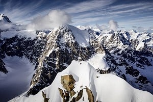
Much of the lower hiking was pleasant enough in the forest, but not much views. The views higher up are great: Even though you're not on a high peak, you're surrounded by spectacular peaks, and nice views down over the valley of Cortina.
Parking: From Cortina d'Ampezzo I drove North on the main road toward Dobbiaco / Toblach. After about 5.7 km at at sign saying "Capo Verde" and "Val di Fanes" (lat/long approx N46.586 E12.113) I turned Left, then continued North on an asphalt road parallel to the main road, for about 0.8 km and Parked (lat/long approx N46.5933 E12.1134) - (altitude ~ 1280m).
Approach hike: I started walking North on the asphalt road, soon passed lots of trail signs and an information hut. Reached a fork after about 200m, bear Left onto trail 417, continue NW for 600m and cross a bridge. Next the trail turns South, a wide gravel forest road. About 800m reach the junction for trail 447 (the descent route), and continue straight South. About another 1000m on the wide forest road reach another junction -- turn Right on trail 408 and go uphill West (nice trail) about 1500m to a junction by Forcella Posporcora (altitude 1720m).
Turn Right and just a few meters higher reach the junction (N46.5825 E12.0955) for the Via Ferrata trail. Turn Right on this, much steeper, not so nice. At first up NNW about 350 meters, then generally up East (with some red paint markings and one short cable) with some NE then SE, then reach a cave with the metal plaque for the VF route, and a little farther to the bottom of the main via ferrata cables (N46.5843 E12.0962) - (altitude ~ 1950m).
Climbing: The main VF cable section goes up about 120 vertical meters roughly North. Then there's more scrambling roughly North, some gentler walking (some red paint marks, two very short cable sections) curve NorthEast, then East, to a last short rock section with three short sections aided by metal rungs (but no cable).
Summit of Col Rosa is at (N46.5858 E12.0977) - (altitude 2166m).
Note that "col" in this region of Italy has the meaning of a hill or mountain (unlike French or English, where it normally means a pass between mountains). Similar words to "col" might "colle" or "colline". Italian language in this region uses "forcella" or "pass" for the concept of the English word "pass".
Descent: Trail 447 is marked from very close to the summit. After brief NW, it heads generally N about 450-500m. There's a tricky point around (N46.5903 E12.0986) (alt 2020m) where need to leave the gully, turn R at a cairn, and go East about 85m, then resume down North about 250m then East about 500m, finally SouthEast about 750m to meet the wide forest road 417. Turn Left on this and go North to the bridge, then SouthEast back to Parking.