In reply to Dave Perry:
This is good info
Fell Top Conditions on Friday 30 January
Readings from Helvellyn summit at 13:10
Temperature minus 3.8°C Maximum wind speed 34.8mph Wind chill minus 14.5°C Average wind speed 11.1mph Wind direction NW - N
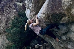
There is snow and/or ice on paths at almost all levels. Although snow depth rises with height, the actual depth encountered varies from little on windswept areas – such as parts of the summit plateau – to drifts of over 60cm (the length of my ice axe!) mainly on east through to south facing slopes. Composition of the snowpack also varied from soft snow and spindrift to hard neve – sometimes on slopes with the same aspect. The snow has been compacted on popular routes into hard snow and ice. The summit plateau was covered in ice.
Cornices have formed above east facing slopes, so please keep well back from the edge and advise those with less experience to do likewise.
Exposed routes, such as Striding and Swirral Edges, are in winter condition and should only be attempted by those experienced in, and equipped for, winter mountaineering including the ability to assess the stability, or otherwise, of the snowpack. Striding Edge had everything today from dry rock, to ice, soft snow and hard snow. Banks of unavoidable, steep snow form the exits to both edges; although Striding Edge’s was mainly soft snow both require the use of crampons and ice axe.
Full winter clothing and footwear are essential for those venturing onto the fells; for those attempting, or traversing, steep routes an ice axe and crampons are also essential.
Met Office forecast for Saturday
Issued 31 January at 04:09
Mainly dry throughout the period, with some lengthy spells of bright winter sunshine, particularly over the southern half of the park. Showers will affect the area at times, and these will fall as snow to all levels with further accumulations. These showers most likely in the north and west towards Skiddaw, Saddleback, Ennerdale and Wasdale although anywhere could see one or two through the day. An organised band of showers moving from the north during the evening could give a more prolonged period of snowfall.
0600 to 0900
Partly cloudy 30% chance of precipitation
0900 to 1200
Sunny intervals 20% chance of precipitation
1200 to 1500
Sunny intervals 20% chance of precipitation
1500 to 1800
Light snow showers 30% chance of precipitation
1800 to 2100
Light snow showers (night) 40% chance of precipitation
2100 to 2400
Partly cloudy 30% chance of precipitation
Visibility
Very good or excellent, with panoramic views of surrounding snow-covered fells. Temporarily poor or very poor in any showers, and also in drifting snow due to the strong winds, particularly on higher areas.
Hill fog
Occasional patches down to 400m during the early morning, then associated with any snow showers for the rest of the day.
Wind at 500m
Northwesterly 40-45mph with gusts of 60-65mph. Gusts of 70mph possible on exposed ridges during the evening.
Temperatures
Valleys/low level: Minus 1 Celsius rising to plus 2 Celsius during the day, falling to minus 2 Celsius during the evening.
At 900m: Around minus 5 Celsius.
Freezing level: Freezing level around 200m.
Daylight
Sunrise in Glenridding: 08:02 Sunset: 16:49 - from time.is
Hazards
Storm force winds
Medium risk - Gusts of 70mph possible on exposed ridges during the evening.
Gales
High risk - Gusts expected to reach 55-60mph on exposed summits and ridges.
Severe chill effect
High risk - Strong winds and low temperatures will combine to give a severe chill effect.
Persistent extensive hill fog
No risk
Thunderstorms
No risk
Heavy persistent rain
No risk
Strong sunlight
Medium risk - Glare off the snowpack in any sunny spells.
Blizzards
High risk - Strong winds leading to blizzard conditions at times, even without falling snow.
Heavy snow
Low risk - Showers could merge to form longer spells of snow, particularly during the evening.
Forecast for Sunday
Snow showers continuing during the early hours, before dying out towards dawn. Then a bright, cold, and sunny winter's day. Still a risk of the odd snow flurry, more so towards the coast, but most places staying dry all day. Remaining dry into the evening with long clear spells allowing a sharp frost to form.
Visibility
Generally very good or excellent, but temporarily reducing to poor or very poor in any snow showers. Blowing snow reducing visibility at times on the highest areas.
Hill fog
Occasional patches down to 400m associated with showers in the early hours. Then most summits completely clear all day save for the odd patch at 700-800m.
Wind at 500m
Northwesterly 40-45mph with gusts of 65-70mph easing to 30-35mph with gusts up to 55mph possible during the afternoon.
Temperatures
Valleys/low level: Minus 1 Celsius at first, rising to plus 2 or 3 Celsius for a short time in the afternoon, before falling quickly after dark to minus 3 Celsius.
At 900m: Around minus 7 Celsius.
Freezing level All levels, rising to around 300m for a short time on sunlit aspects and towards the coast.
Outlook for next few days
Monday
A bright and mainly dry day with some lengthy spells of winter sunshine. A low risk of the odd snow shower, mainly towards the coast. Moderate northerly winds. Freezing at all levels at first, rising to 400m later.
Tuesday
A largely clear and bright day but a risk of the odd wintry shower. Moderate to strong northerly winds. Freezing level at the surface, perhaps rising to 400m on sunlit slopes and near the coast during the afternoon.
Wednesday
Another cold and bright day, with a risk of the odd snow shower on the western fells. Moderate north or northeasterly winds. Freezing level around 200m.
Recent conditions
On 30 Jan 2015
Click on photo to see full version
More details about Teko socks Click here to buy Met Office-inspired clothing The Kings Arms in Keswick