


1:40,000 scale - waterproof map - £9:95 members, £12:95 non members
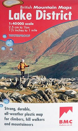
Innovations in the world of maps are pretty rare but this new Lake District map produced by a collaboration between the BMC and Harvey's Maps has won an award for just that. The annual award is in recognition of UK innovation in the outdoor world and is presented by the Outdoor Writers Guild. The innovation can be of any kind, and the winner is selected by a panel of 'experts'. On this occasion the BMC President Mark Vallance, (whose idea the map was), accepted the award for the BMC at the OWG Annual Dinner in Lancaster in November. Apparently any surplus made by the BMC from the sale of the map will be used to fund work programmes including access, conservation, safety and good practice.
So what's it all about. There have long been attempts to print maps onto plastic at a reasonable cost and it has proved quite a technical challenge - the military have had them for a long time but of course theirs is a 'moneys no object' world, unlike the one the rest of us live in. In fact waterproof maps have been around for years - I have a Harvey Mountain Map to The Peak at this very scale from the 1980s described as a Duxbak (as in 'water off' - geddit?) and although shower resistant it does feel a bit fragile compared to the new Lakes map.
© Harvey 2005
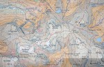
Also on the rear is a small inset of Great Calva, it wouldn't fit on the front but is included for people who want to do the Bob Graham round - an excellent idea.
The main climbing crags are marked (in an oddly difficult to read red print) and useless clutter such as parish boundaries have been removed. Also on the back of the map is a section on How to use a Map and Compass, initially I though it an odd thing to have on a map but on second thoughts maybe its the most logical place to have it! And exactly the same argument goes for a "What to do in the event of an accident" section also on the map's reverse. There is also a useful set of phone numbers and web addresses for Information Centres, the weather, birds etc.
The only think that hasn't worked is the geological map, the final piece in the jigsaw that makes up the reverse of the map. The key to it is fine, but the actual map is so 'soft' that teasing any information out of it is impossible - pity really.
The map was even given the seal of approval by Lord/HRH/Sir Bonners himself - so it must be good. I will add my recommendations to his and give it 9.5/10, all in all an excellent job. I trust we can look forward to similar maps of Snowdonia, The Peak, Glencoe, Skye and the Cairngorms in the future. Sort out (or dump) the geology maps and they will have a winner.


Comments