Rockfax Description
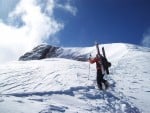
This remote via ferrata tucked away at the head of the Val San Nicolò was originally equipped in 1915 by the Austrian Kaiserjeger troops because of its obvious strategic position. The via ferrata was then restored in 1996 and now serves as an excellent day out. The approach is long but very scenic. The via ferrata itself is inconsistent with some steep sections that are difficult for the grade alternating with much easier slab climbing. The rock throughout is pretty loose and care must be taken. Whilst the climbing itself isn't the best in the area, the views and situations are superb. The route is highly recommended to those seeking a long and beautifully scenic day out.
Approach - The impressive peak of Col Ombert is situated at the head of the Val San Nicolò, a beautiful valley running east from Pozza di Fassa. From Canazei, take the SS48 to the west in the direction of Campitello. After 11km you will reach Pozza di Fassa just past Pera. Drive through the centre of the town following signs for the 'Val San Nicolò'. Follow the road past Rifugio Malga Crocifisso and a small chapel on the right to where the road forks. Turn left and continue to the end of the road and the entrance to the Val San Nicolò. Park in the large stewarded car park on the right. Go back out of the car park passing over the bridge and then turn right up the valley following the large track (and many tourists). Continue past Rifugio Baita Ciampie until after 20 minutes the path forks. Turn left, ignoring path 641, and staying on the 608 following signs for 'Passo San Nicolò'. A further 10 minutes brings you to another path junction. Here a newly built path leads off to the left, signed to the 'Col Ombert Via Ferrata'. Confusingly the path is marked 608 as is the main track leading straight ahead. Recently the authorities have tried to denominate the new track 'P01' and you will see both markings - regardless of the name of the road, you get a choice of route. The main track leading straight ahead leads to Rifugio Baita alle Cascate before turning north up to Passo San Nicolò and the rifugio by the same name. Path 'P01' turning off left goes up steeply north through the woods to join path 613 which then leads southeast to Rifugio Passo San Nicolò. Both are equally pleasant, well signed and bring you to the rifugio in about an hour. For some variety it may be worth ascending 'P01' as it is a bit steeper and then descending the 608 main track later in the day. © Rockfax
Feedback
| User | Date | Notes | ||
|---|---|---|---|---|
| Mimoo | 21 Sep, 2023 |
Show βeta
βeta: Need to park and get shuttle bus to Val San Nicolò from Soldanella (open car park near Soldanella restaurant). No public vehicle access beyond this point. | βeta? | |
|
Show beta
βeta: Need to park and get shuttle bus to Val San Nicolò from Soldanella (open car park near Soldanella restaurant). No public vehicle access beyond this point. |
||||
Logged Ascents
Guidebooks for Val San Nicolo
Not all climbs at crag may appear in this book 7 users have this on their wishlist
Please Login to view more details on the logged ascents
Marmolada West Ridge to Punta Penia (VF)
Grade: VF4C ***
(Marmolada)