Climbs 1
Rocktype Gritstone
Altitude 506m a.s.l
Faces all
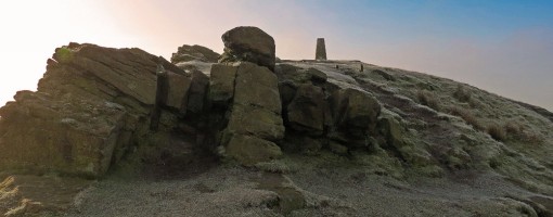
Shutlingsloe summit © David Carpenter
Crag features
Shutlingsloe is a hill near the village of Wildboarclough, in the east of the county of Cheshire. It stands to the south of Macclesfield Forest, on the edge of the Peak District and within the Peak District National Park.
A steep-sided hill with a distinctive profile, sometimes described as the 'Matterhorn of Cheshire', it is the third highest peak in the county (Shining Tor being the highest and Whetstone Ridge second highest) with an elevation of 506 m (1,660 ft), and commands excellent views over Cheshire.
The name derives from old English 'Scyttel's hlaw' meaning 'Scyttel's (personal name) hill' and is one of several 'low' names in the Peak District, from the same Old English root that gives rise to the name "Law" for many hills in southern Scotland.
Approach notes
Lies on Access Land
| There are no comments from visitors to this crag. |
Climbs at this crag
| Name | Grade | Stars | Type | Logs | Partner Ascents |
|---|
These climbs you have climbed by seconding or top-roping.
These climbs you have Dogged.
These climbs you Did not Finish.
Climbs are waiting to be checked by a crag moderator, and may not be accurate. Climbs can't be verified by a crag moderator, and they need more information to confirm it. Climbs are no longer climbable.
Moderators Updates to this page are checked by a UKC volunteer ChrisHolloway1