Climbs 2
Rocktype Limestone
Altitude 191m a.s.l
Faces NW
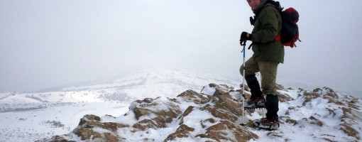
Crampons on Crook Peak. © deepstar
Crag features
The site extends for some 5km from west to east. Near its eastern end it is divided by a gap used by the A38 road and the disused Cheddar Valley railway line. From west to east the site includes these hills:
Crook Peak, reaching 191m (627 ft), a prominent feature from the surrounding landscape. Evidence of early human occupation includes a polished flint axe.
A ridge to the southeast of Crook Peak, known as 'The Razor', is used by the West Mendip Soaring Association to fly model aircraft in south-westerly/southerly or north-easterly winds.
Approach notes
King's Wood between Cross Plain and Shute Shelve Hill is owned by the National Trust operate a small carpark.
| Walked up from North Quarry with Compton. Good breeze and got to summit in time to see sunset on shortest day of the year leland stamper - 21/Dec/14 |
Climbs at this crag
| Name | Grade | Stars | Type | Logs | Partner Ascents |
|---|
These climbs you have climbed by seconding or top-roping.
These climbs you have Dogged.
These climbs you Did not Finish.
Climbs are waiting to be checked by a crag moderator, and may not be accurate. Climbs can't be verified by a crag moderator, and they need more information to confirm it. Climbs are no longer climbable.
Moderators Updates to this page are checked by a UKC volunteer leland stamper