
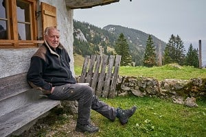
John Ross writes about walking in New Zealand in 2009, taking in both the North and South Island with their glaciers, mountains and assorted flora and fauna along the way.
John spent his working life teaching modern languages in Glasgow. He played golf for much of that time but the game eventually yielded to his preference for the Munros and all but 30 Corbetts, and he became a member of the Lomond Mountain Rescue Team.
"I dislike being called a rambler, but admit to being a scrambler rather than a dangler. I had an ambition to climb all the Ben Lomonds outside of Scotland but have only done those in Utah, Tasmania and NZ."

© J.P. Ross
This piece dates back to September-November 2009. The delay can be put down to a mixture of golf and writer's cramp, mainly the former.
I regularly visit New Zealand where I have a daughter in Rotorua, a son in Gisborne and three grandsons. Over the years, I have done some great walks, including Ben Lomond above Queenstown, the Kaweka Range up country from Napier and the crossing of the magnificent Tongariro National Park. Recent visits, however, have seen me increasingly seduced by some fine golf courses including Arikikapakapa [Place of Splashing Waters] in Rotorua where a ball hit off-line can land in a pool of boiling mud or a fissure emitting clouds of steam.

© J.P. Ross
The weather in Gisborne had not been great, with a Southerly approaching, when I chanced on a forecast for South Island - a week's sunshine on the west coast. I grabbed rucksack, tent, boots and golfbag, caught a bus to Wellington, had dinner with an old friend and took the InterIslander to Picton. The crossing of the Cook Straight is stunning, with Mollymawks impersonating "real" Albatrosses and Cape Pigeons flashing about. Just as the ferry is about to plough into the cliffs of South Island it swings off into the beautiful Marlborough Sound, with Picton at its head.
I duly picked up a car and headed south. I could not resist a quick 9 holes when I saw the sacreligious sign outside Picton Golf Club: "Smile, it's only a game!" You'll never see that at Panmure. In September there were Merino lambs running about, a few llamas looking over a fence and the omnipresent bell-like calls of Magpies [same ones as in Oz] and Bellbirds. On through the vineyards of the Wairau Valley, after which one could almost be in British Columbia with pine forests sloping down to wild, untamed rivers.

© J.P. Ross
I reached the coast at Westport and, heading south, stopped to visit the Pancake Rocks at Punakaiki. This is a fascinating layering of limestone which looks like pancakes stacked on a plate and some spectacular blowholes. I then passed Greymouth and the site of the impending Pike River Mine tragedy. I camped south of Hokitika and in the morning enjoyed the attention of a Weka, a flightless bird, pecking at my boots with obvious and successful designs on my muesli. My next stop was the former goldmining town of Ross, where I visited the old cemetery to check out my ancestors, Not a Ross in sight. The original settlers seem to have been mainly an eclectic mixture of non-Scottish Europeans.

© J.P. Ross
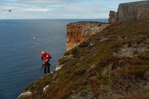
South of Ross the backdrop is the Southern Alps. I decided to take the Alex Knob Track - an 8-hour round trip up to 1304 metres with a fine view over the Franz Josef Glacier.

© J.P. Ross
The Franz Josef Glacier in the Tai Poutini National Park is 12 km long and presently descends, like its neighbour the Fox Glacier, into the temperate rainforest at less than 300m above sea-level. Its length depends on variations in the snowfield which feeds it and it is currently in a phase of rapid retreat. It is reckoned that there will be 38% less of it by 2100.
Franz Josef is the boring name. Maori legends are always much more appealing. "Ka Roimata o Hinehukatere" translates as "The Tears of Hinehukatere". Hinehukatere loved climbing and took her lover Wawe with her. A less experienced climber, he had the misfortune to be swept down by an avalanche. The tears of the devastated Hinehukatere froze and formed the glacier.
As I left my car, a Kea landed on it with a decidedly predatory look in its eyes. The car was fully insured so I went on my way. The bird [a mountain parrot and well worth googling] must have been well fed as the car was still in one piece when I got back.

© J.P. Ross
The track zigzags up a steep and probably rather exposed slope. As it is mostly through bush the exposure gave me no problems. The normal weather pattern here is for morning sunshine giving way to cloud. I was lucky as the cloud developed only after I got back down in the evening. Alex Knob is in tussock grass terrain above the snow-line with a fine view over the glacier and surrounding peaks. This should have been a grand wilderness experience but helicopter tourism put paid to that hope for much of the day.
When I got back to Franz Josef town, I realised I still had not seen Mount Cook so I took a road west and cooked a meal beside the car with fine views to Mounts Cook and Tasman lit by the setting sun. I was now so tired that I crashed out in the car and woke to see the aforesaid mounts lit by the rising sun. The morning cloud arrived at the same time as the first tourists. It's uncharitable, I admit, but I did enjoy a vague feeling of schadenfreude, having already got my photos in the can.
By now the weather forecast was not so good so I went south to take a quick look at the Fox Glacier. I walked up to the snout to find a notice indicating that further progress was only allowed if with a guided group.
"Glacier Guided Groups only". " Aye right", I thought. Not even in New Zealand does anyone own a glacier. So on I went. A well-trodden path led up the side of the glacier, then down and up steps cut in the ice to the top. Half way up, I duly met a group whose leader pointedly observed that his company had made the steps. I politely thanked him which did not go down too well . "What if you have an accident?" I said that in my country if he had an accident a Mountain Rescue Team would collect him, patch him up and put him in an ambulance without grumping at him. "OK" he said, "Point taken. I've been there." We parted amicably . He seemed to be aware of Scottish attitudes to access. I made my way to the top, took some photos and headed back down in one piece. Later, I was on a flight of wooden steps on cliffs above the glacier when I met another group. "So you must be the wandering Scotsman?" said the leader, "I got a radio call…"

© J.P. Ross
This was another fine walk with some memorable birdlife including many Paradise Shelducks on the glacial lake at the end of the valley and a wee, specially imported ca 1860, Dunnock, hopping around beside the snout of the glacier.
I was chased north by an advancing front and escaped over Arthur's Pass to stay for a few nights with friends near Christchurch. This was not long after the first earthquake and the only obvious signs were the liquefaction of a bunker on the Hagley Park course and the aftershock which shook the whole house just as I was shutting the fridge door after breakfast.
I had always wanted to visit the port of Lyttelton, from where Shackleton sailed for Antarctica in the Nimrod in January 1908. Unfortunately, I was seduced by an attractive ridge above the town with fine views over the Banks Peninsula [hills of Munro height] and spent a very pleasant evening walking round it. The town was massively damaged in the second earthquake, so a return will have to be put on ice.
Back in Gisborne, I was delighted to be invited by friends of my son to fulfil my main remaining, achievable ambition in New Zealand, to see the sunrise from the summit of Mount Hikurangi on the East Cape.

© J.P. Ross
I'll do the science bit first.
Mt Hikurangi is one of several spectacular sandstone peaks on the south side of the Tapuaeroa Valley and at 1752m is the highest non-volcanic peak in the North Island.
This region is extremely complex geologically and tectonically...as happens when you are astride a plate boundary! Put simply, the bottom part of Hikurangi is in-situ Cretaceous sandstone and the upper part is out-of-place older greywacke sandstone which has been thrust up and over the top. I have a much more detailed description which I had thought of passing off as my own but I would never have got away with it.
Hugh, a fisherman from Manchester, his wife Hera and I set off to enjoy the beautiful drive up the East Cape to Ruatoria, passing Tolega Bay, famous for its connections with Captain Cook's explorations. Happily, Hugh had obtained permission to take his old 4x4 from the Pakihiroa Station up the farm track to a point below the Hikurangi Hut, cutting out what would have been a horrendous 1200 metre slog [point taken, but Hikurangi is neither a Munro nor a Corbett, so I was happy to jettison my purist principles]. This area is used for sheep and cattle farming and is actually rather depressing, having been deforested and with remnants of fine old trees lying everywhere. The wilderness experience was further spoiled by the constant noise of an aircraft spraying lime to maintain the limited yield of grass.
Mount Hikurangi is the first point on mainland New Zealand to catch the morning sun. It is the highest point in the rugged Raukumara Range and is revered by the Ngati Porou tribe as its sacred mountain. For them, it is, more importantly, the resting place of Nukutaimemeha, the waka[canoe] of Maui, who is said to have fished up the North Island of New Zealand. The association of people and mountain is recorded in song, haka, proverbs and incantations. Some fine wooden statues were erected at the Millennium to reflect this relationship.
We arrived at the hut in thick mist. At midnight, I had to pop outside and was amazed at the change. The mist had lifted, the sky was awash with stars, dominated as always by the Southern Cross, and the moon was about to rise in the north-east. There were no complaints when I woke up the occupants of the hut to come and take a look.
We were up at 3.30am and off by headtorchlight at 4am.

© J.P. Ross
A steep, grassy scramble behind the hut leads into southern beech forest [no sign of either Hobbits or Onodrim] followed by subalpine scrub until one emerges above the bushline. From a lochan there are fine views of the interior of the Raukamura Range with the precipitous summits of Whanakoa to the north-west, its highest peak so rugged that it was only climbed in 1946 by Colin McLeron and Adrian Primrose. This is harsh country, where off-track travel is only for those who enjoy a good thrashing [Kiwi speak]. The route then leads across tussock slopes dotted with clumps of prickly speargrass, North Island edelweiss and large buttercups. A long, steep-sided scree gully, inhabited by a pair of not often seen NZ Falcons and some seriously alarmed Pipits, leads to a bealach from where an exposed scramble leads to the summit and the trig point.
By this time the sun was just above the horizon giving unforgettable mist and cloud effects and fine views over surrounding peaks and north and east to the South Pacific Ocean.

© J.P. Ross


Comments