
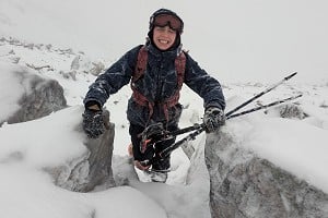
In this three-part series, Pete Reynolds AKA 'The Lakeland Rock Doctor' takes us on a tour of the varied and interesting rocks of the British Isles upon which we love (or occasionally hate) to climb...
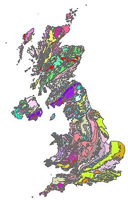 © British Geological Survey
Part 1: Igneous Rocks
The British Isles are composed of a remarkable combination and variety of rock types assembled over millennia. We can never hope to understand all their curios and quirks in a short series of articles, or even a lifetime. However, this series provides some insight into the geological history of Britain, as well as explaining how Earth processes ultimately influence our leisure, craft and profession. The articles are divided according to the 3 main types of rocks (igneous, sedimentary and metamorphic). We begin the series with a look at igneous rocks - those solidified from magma or lava. Igneous rocks form many iconic features in Britain, including Napes Needle on Great Gable. The first ascent of this needle in 1886 is argued to have heralded the birth of British rock climbing. It therefore seems a fitting place to start our investigation of Britain's geology.
Igneous rocks can be broadly classified into two types; extrusive and intrusive. Examples of extrusive rocks include andesite, basalt and rhyolite. These have been erupted from volcanoes as either lava flows or pyroclastic rocks (literally meaning "pieces of fire"). These rocks cool at the Earths' surface and are found in abundance in Snowdonia, the Lake District, Glen Coe and Ben Nevis. Pyroclastic rocks are often referred to as "tuffs" or "breccias" depending on the size of the fragments in the rock. Watch a YouTube video of Mt. St. Helens erupting to see how pyroclastic rocks are emplaced; great umbrella clouds of ash darken the sky and avalanches of superheated rock bulldoze the landscape. Simultaneously, the erupting volcano tears itself apart. Imagine similar, but far grander eruptions occurring in Langdale, and you'll understand how the lumps, bumps and blocks in the rock got there.

But why did these ancient eruptions occur? We only have to look at the Earth's tectonic plates to understand why. The plates are either moving past each other sideways, colliding or pulling apart. In places where the plates are colliding, one plate can be forced beneath another along a "subduction zone". This melts the lower plate in the mantle and produces lots of magma. Such a scenario is occurring along the western margin of South America, and is the reason we find volcanoes in the Andes. The Lake District, Glen Coe and Snowdonia were also once sat on a subduction zone, and the volcanic rocks which form the rugged scenery are the products of these plate collisions. In contrast, the basaltic lavas along the west coast and islands of Scotland formed when North America separated from Scotland. In doing so, eruptions similar to those in present day Iceland produced enormous lava flows that provide angular, slopey holds, such as on the crags of Mull.

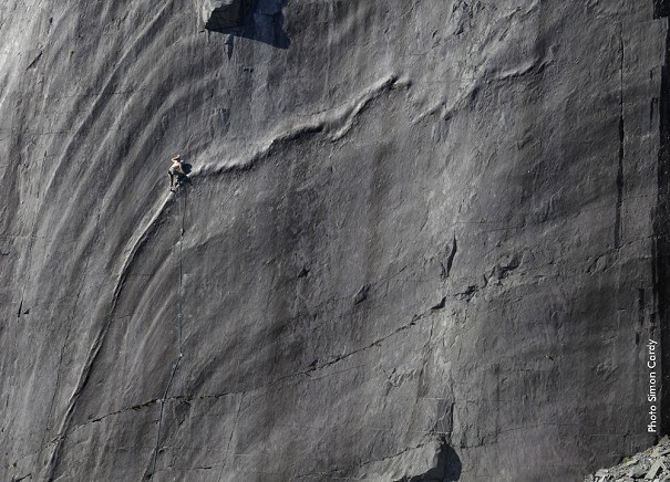
Common types of intrusive igneous rocks are granite and gabbro. These represent ancient magma chambers that have solidified beneath the surface of the Earth. The magma chambers are thought to be shaped like a giant pond, rather than the blob-shaped pictures you'll find in cartoons of volcanoes. Give these ponds a good few millions of years to cool off, and they will eventually be sucked toward the Earths' surface through weathering and erosion. These erosive powers continue to play an important role in shaping the mountains today. For instance, the percolation, freezing and thawing of water in cracks gradually jacks open and widens cracks. Of course glaciers have also played their part; these are the butchers of erosion whereas freeze-thaw weathering is the make-up artist.
In contrast to the large magma chambers that characterise large swathes of Scotland and the South West, other intrusive igneous rocks are shaped like vertical or horizontal sheets. Take, for example, Kilt Rock on the Isle of Skye. This crag formed as a result of the injection of magma between horizontal layers of sediment (the sediments are the choss at the base of the cliff and have largely been eroded from the top). Note that Kilt Rock is characterised by abundant vertical cracks and columns – these formed as a result of contraction of the magma during cooling. The cracks define how the rock weathers, commonly forming pillars and tall blocks.

In other cases, magma is injected near vertically, such as the dykes found amongst the Cuillin. If you need an excuse to get down on your hands and knees whilst doing the Cuillin traverse, take a close-up look at the dykes and gabbro. You'll notice that the gabbro is composed of interlocking, angular crystals. The dykes are composed of these crystals as well, except they are a lot smaller. This is because the dykes have cooled far quicker. As a result, the dykes are far more slippery than the surrounding gabbro. Crystal size and hence cooling rate in igneous rocks thus play an important role in friction.
Now look at a map of the geology of Britain. Note that many of the mountainous regions of Britain are sculpted from igneous rocks. These fells and buttresses have resisted the abrasive action of glaciers better than the surrounding sedimentary rocks, and so form the high topography. On your next trip into the mountains and fells, whether it be the Lakes, Glen Coe or Snowdonia, ponder the magma and lava from which these mountains cooled. Then look as the crags slowly tumble, collapse and erode; every rain drop and frost-ridden crack gradually wearing away at their face, slowly turning their proud buttresses to sand and dust. It is this gradual nagging of the wind, ice and waves that slowly turn all our mountains into dust, ready to be preserved and reborn as a sedimentary rock – the topic of the next article.
UKC Articles and Gear Reviews by Peter Reynolds


Comments
You've missed out Shetland from the map, location of some of the most complex and varied geology in the UK, and some outstanding climbing too!
This is a useful interactive map to complement the article.
http://mapapps.bgs.ac.uk/geologyofbritain/home.html?
Hi Keith
There's an interesting App for Android called iGeology. Look it up in the Playstore. (If you're at the wall tomorrow, I'll demonstrate it)
This later version of the BGS viewer is better:
http://mapapps.bgs.ac.uk/geologyofbritain3d/
And high-res scans of the 'actual' maps sheets can be viewed here:
https://www.bgs.ac.uk/data/maps/maps.cfc?method=listResults&MapName=&series=S50k&scale=&pageSize=100
Click on the 'Full Entry' link, then hunt out the small 'View Map' Link
Using this web-site makes it easier to work out what sheet you need for an area:
https://geologyresources.co.uk/maps/