


Until recently, however, this revolution has been a pretty static one, at least physically. Google Maps is great when you're sat in front of a monitor, but we all still take a real paper map for a day on the hills. Likewise, online 'journey planners' are great to use from the comfort of your own home, but most of us still check the timetable at the bus stop. And of course, one can spend hours perusing the various climbing topos and logbooks online, but then still take a good-old fashioned guidebook to the crag.
All that's changing, though. The digital revolution has gone mobile, and if you're not one of the millions of people who've got a 'smart' mobile device, then you're missing out! There are now countless 'apps' (small software programmes designed to be downloaded and used on your mobile device) and web-services that let you take the digital revolution with you in your pocket, everywhere you go. Naturally, several of these apps and services are designed for climbers and mountaineers, and in this two-part article, we're going to be reviewing a handful of the best ones developed so far, and peering through the looking glass to see what the future will bring.
Where are these apps?
There are now several platforms for mobile apps. While Blackberry has been the de facto 'business' smart-phone for several years, currently the two leaders in the leisure market are the ubiquitous iPhone (or iPod Touch), from Apple, and the up-and-coming Android platform, provided by Google but running on devices made by a variety of manufacturers. There is little difference between the two in terms of performance, but there is currently quite a large difference in availability and use of apps – at the time of writing there are over 250,000 apps available to buy for the iPhone, about 3-5 times more than for the Android (depending on where you get your stats). It's no surprise, therefore, that there are proportionally more climbing and mountaineering apps for the iPhone than any other device. However, the up-and-coming HTML 5 (a new web standard that enables multimedia rich websites) in theory will run nearly identically on almost all smart mobile devices, and should lead to less platform specific apps in the future.
Rock Climbing Apps
Bouldr (iPhone/iPod Touch, £1.79, iphone.bouldr.net)
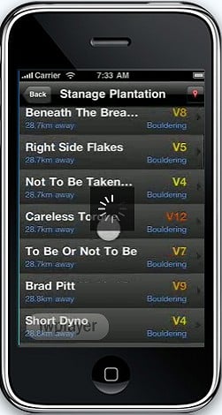
Probably the leading 'guidebook' application at the moment, Bouldr relies on the power of crowd sourcing to provide locations and photo topos for a variety of different climbing areas. It uses the GPS functionality of your iPhone to determine exactly where you are, which then lets you find your nearest crag, and even your nearest route! Photo topos with route overlays complete the package. Sounds amazing – but its greatest strength is also its largest flaw: by relying on the public to submit photos and topos, its coverage could be termed 'patchy' at best – it currently only lists 700 routes/problems in the whole of the UK. It's still very promising though – the more users it has, the better it will get, and a recent price reduction will accelerate that process. If it becomes as successful as EveryTrail (see below), then it will be really impressive.
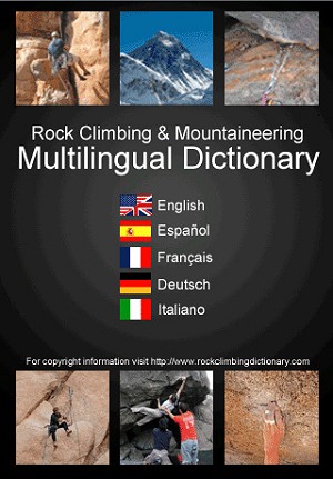
Climbing and Mountainering Dictionary (iPhone/iPod Touch, £1.19, rockclimbingdictionary.com)
While many 'Dictionary' apps on the Apple Appstore could be more accurately described as 'glossaries', the Climbing and Mountaineering Dictionary is multilingual dictionary that translates hundreds of technical climbing and mountaineering terms between 5 languages: English, Spanish, French, German and Italian. Given that many of these terms don't appear in standard dictionaries, this app comes into its own when trying to understand foreign guidebooks, or converse with climbers abroad. The interface is attractive and fast, and photographs or illustrations are provided for each term, removing any doubts about meaning. An essential purchase for the travelling climber.
Climbing Grade Converter (iPhone/iPod Touch, £0.59, bluefusiongames.com)
A simple application that converts climbing grades across 13 different grading systems. Although there are grade conversion charts littering the web, when abroad (or an in area of poor network coverage) you're unlikely to be able to access the internet, so having an installed application with data stored offline is a real asset. Another useful travel climbing app.
Knot Guide (Android/Palm Pre/iPhone/iPod Touch, from £0.59, winkpass.com)
While most rock climbers can tie the essential two or three climbing knots with barely a thought, when a situation calls for a more complex knot, many of us make a couple of half-remembered attempts, before likely bodging around the situation with a nest of clove-hitches and karabiners. As a result, a mobile knot instructor is a handy app to have, and there are several available both for the iPhone and Android. One of the best is the simply titled Knot Guide:Climbing, which presents step-by-step instructions on how to tie 17 useful climbing knots. A valuable resource at a very reasonably price.
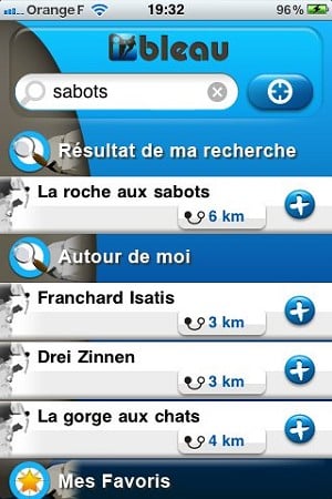
This French language app is an iPhone guide to the world famous bouldering in the forests around Fontainebleau. At £2.99 it is a little on the pricey side, but you do get photo guides to several of the popular areas, such as Franchard Isatis and Rocher aux Sabots, and GPS support to help you find the nearest areas covered. Once nice touch is the links to online videos of certain problems, in case you're in need of a bit of beta! Unfortunately it's no replacement for a standard guidebook, and the presentation and user interface is a little cluttered and confusing. Possibly a sign of things to come, though?
Mountaineering, Walking and Running Apps
Army Climbing (iPhone/iPod Touch, £1.19, doubledogstudios.com)
Apparently, Army Climbing is a faithful digital reproduction of the US Military official training guidebook, Military Mountaineering. While there is certainly a debate to be had on the practicalities of reading an e-book on the iPhone's small screen, there's no doubt that this app offers a phenomenal amount of excellent information for only a fraction of the price of a standard training book. Covering all aspects of climbing, mountaineering and navigation, its logical user interface, plethora of photographs and comprehensive index mean that it is a very useful quick reference guide. While it doesn't give you anything that a decent book doesn't, it weighs less and costs less, and is difficult not to recommend.
MotionX GPS (iPhone/iPod Touch, £1.79, gps.motionx.com)
My Tracks (Android, Free, mytracks.appspot.com)
The GPS functionality of many smartphones has resulted in an overload of 'me-too' apps, for all platforms, which inform you of your current latitude and longitude. While this information on its own is very useful for mountaineers stuck in a whiteout, or those wishing to record the location of a shelter or gear stash, there are a few more comprehensive apps that are worth hunting out. Motion X GPS for the iPhone, and a free alternative for Android, called my My Tracks, both track your movements over a period of time, link in with downloadable maps (from Google Maps and elsewhere), and can even give you an estimate of your current altitude. The apps are also particularly useful for those out jogging or fell-running, as they can tell you how far and how fast you've been running for. It should be pointed out though that these are not designed to compete with turn-by-turn GPS devices (such as the Tom-Tom), and that using the GPS drains battery at an alarming rate!

World Peaks is an Augmented Reality (AR) application that points out mountains and peaks seen through your device's camera, using GPS and compass location to overlay text and graphics onto the video feed. It is available as an individual app from the Apple Appstore, or as a plugin for the general AR app Layar (http://layar.com), available for both the iPhone and Android devices. This is a really nice idea – I'm sure most people who have ever admired a beautiful mountain view can see the attraction of instantly putting names to the various peaks; and due to the generally long distances involved, the occasional 10-15m error in the GPS location is largely irrelevant. You have to download peak information for each country, but the data is very comprehensive, even pointing out small hills of a few hundred metres. The main complaint is that the iPhone compass can suffer badly from interference, which gives some directional errors if you're near lots of metal, and the actual app itself has a few bugs. However, it's a very nice idea, and reasonably well implemented.
Hill Lists (iPhone/iPod Touch, £0.59, grahamhaley.co.uk)
Hill Lists is very popular UK based application that is essentially a database/logbook for all the major mountains and hills in Great Britain. It uses Google Maps data to point out the hill locations (and, thus, requires an internet connection for the full experience), and lets users 'tick' and add notes for each hill too. The attention to detail in this app is obvious from the word go, and while it is not going to win any points for style, it has a logical and familiar user-interface. A simple and good value app that will appeal to Munro-baggers!
Everytrail (Android/Windows/Blackberry/iPhone/iPod Touch, Free, everytrail.com)
This app, available for pretty much every platform, provides a seamless link with the collaborative hiking routes website, everytrail.com. You can browse from over 300,000 walks that have been already mapped out by others, and contribute your own routes by recording where you go (much like MotionX or My Tracks, see above). The free version is ad-supported, or you can choose to pay for the 'Pro' version, which removes the ads and unlocks some non-essential features. While it may not appeal to the hardcore mountaineer, if you at all enjoy a pleasant walk in the countryside, then this app is must. It comes into its own when you are away from home but fancy going for either for a stroll or a full day's walk, as it's almost guaranteed that somebody will have recorded and recommended a walk nearby. A fantastic app that demonstrates the power and benefits of the collaborative internet!
Next stop: the future. Stay tuned for part 2, where we look into our crystal balls and try to predict the future!


Comments