
'It feels like the worst hangover I've ever had mixed with sea-sickness' was Robin's evaluation of his altitude sickness upon arriving at basecamp and puking his guts out. We were all feeling pretty unwell. For sure, we'd gained a too much height too quickly; however, it was necessary to push basecamp up to a suitable spot past a huge boulder field that our yak and pony herdsmen had insisted on stopping at.

© Kunal Masania, Aug 2011
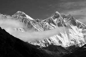
Two flights, three days of bum bruising off road driving and two days of scenic hiking brought us to our base camp in an arena of unclimbed mountains. We were in a western branch of the Raru Valley called Tetleh Valley in the Zanskar Range of the Himalayas. The eight of us aimed to climb the supposedly unclimbed peak (now named Lama Jimsa Kangri) – the highest in the valley at an estimated 6,180m. The team consisted of Johnny Moodie, Dominic Southgate, Robin Jones, Joe Prinold, Johnny Bull, Kunal Masania, myself (Virgil Scott) and our Liaison Officer, Anupam Mukherjee. With so many of us we decided to split into two teams and approach Lama Jimsa Kangri from opposite sides. One team would go up an s-gulley to access a ramp on the East face while the others would climb via the steep icy and rocky slopes of the South-West side.

© Joe Prinold, Sep 2011
Upon reaching the advanced basecamp, the first team spotted a very attractive looking couloir that took a direct line near to the summit. As this required less walking to approach, we were united in the idea of changing lines. The next morning, we trudged up hundreds of metres of steep snow, moving together as a four up the gulley. After about 400m of Grade I slogging with thumping heads, the gulley steepened and became icier – time for two tools. The gradient never exceeded 70° for the next 500m, but our energy was getting low. Whenever the leader stopped to place gear all of the seconds would have their heads propped against the ice in the 'I'm really F'd!' position. At the cornice we played rock, paper, scissors for the finishing lead, Johnny B 'won' and charged up with surprising enthusiasm. One hundred metres of unexpected and morale crushing scrambling beyond the cornice brought us to the summit at 6,276m – some 100m higher than we had thought. The other team had been and gone thirty minutes earlier. We admired the view, noticed an old cairn and piece of faded tat that must've been on this not-quite-virgin summit for at least a few years, and quickly set off down the southern slopes to relieve the feeling that our brains and lungs might stop working. We suspect a team to have ventured over from the nearby Temasa Nala to climb the mountain some time ago.
We spent the next couple of days resting and planning what to do next. Kunal and Johnny B attempted a rocky ridge aiming for a summit of around 5,700m and starting from a camp on the glacier at around 5,100m. Unfortunately, about 150m from the summit, they came to a steep ice field which wasn't crossable as they'd left their crampons lower down when they joined what had appeared to be a fairly continuous rock ridge.
 © Virgil Scott, Sep 2011
It would've seemed a waste not to have a go at the wall right next to our base camp, around 700m of nice looking rock, so Joe and I attempted this next. It turned out to be around 20 pitches between HS and HVS with some very good climbing. We started climbing at sunrise (~6am) and reached the summit just before dark, then descended down a mind numbing scree gulley to the north.
Back at base camp again we each had our own ideas about what to try next. Kunal and Johnny B headed back up the glacier for some rock and mixed lines, while Johnny M, Dom and Robin wanted to have a go at another high peak further up the glacier
Joe and I had our minds set on an east facing rock spur of another peak on the west side of the valley. We camped near the base of the spur at around 5,000m and started climbing at around 3.30am. After 200m of scrambling we arrived at the main spur just after sunrise and started moving roped together, occasionally belaying short sections. Most of the climbing was around HS-VS, with the occasional trickier sections. After about 800m of climbing on absolutely superb slabs the spur steepened and we started belaying. At just below 6,000m, with still at least 4-5 long pitches from the summit we noticed dark clouds coming down the valley, then a few wisps of snow began to fall and we decided to descend. After a cold and snowy night on a ledge at around 5,700m we continued the descent the following day.
Kunal and Johnny B had set off for a rock route higher up the glacier, but adjusted objectives when they noticed bad weather coming in from the Miyar. They went for a mixed line that found a sneaky way of avoiding a large bergschrund by approaching on its left end, they then wound their way back right across the buttress above and took a line between the snow and rock. A direct line may have been possible, but with no screws, they crossed back onto the buttress to gain the upper 80? snow slopes to reach the summit (5,985m) at 3.45pm. The route was steeper and trickier than they'd expected, around mixed III/IV and an overall grade of about TD, 700m, they called it Bhaio aur bheno ki khushi.
Unfortunately, attempts on a another peak as well as Johnny M. & co.s route were thwarted by the start of winter. Several feet of snow overnight meant more routes up the glacier were out of question.
After the long journey back to Delhi and a very interesting debriefing, a huge amount of cricket, malls and Limca ensued.
Photo Gallery - Raru Valley in the Zanskar range of the Himalayas:

© Jonny Bull, Sep 2011 |

© Robin Jones, Sep 2011 |

© Robin Jones, Sep 2011 |

© Kunal Masania, Sep 2011 |

© Jonny Bull, Sep 2011 |

© Kunal Masania |

© Virgil Scott, Sep 2011 |

© Virgil Scott, Sep 2011 |

© Kunal Masania |

© Kunal Masania |

© Kunal Masania, Sep 2011 |

© Kunal Masania, Sep 2011 |

© Kunal Masania, Sep 2011 |

© Robin Jones, Sep 2011 |

© Virgil Scott, Sep 2011 |

© Virgil Scott, Sep 2011 |

© Virgil Scott, Sep 2011 |

© Virgil Scott, Sep 2011 |

© Virgil Scott, Sep 2011 |

© Virgil Scott, Sep 2011 |
The team would like to thank the Imperial College Exploration Board, the Old Centralians Trust, Imperial College Trust, the Mount Everest Foundation, the Welsh Sports Association, the Lyon Award and the Mountaineering Council of Scotland, Peter Hutchinson Designs, Montane, Mountain House and TORQ for their support.


Comments