


80,000 people in the Himalayas are at risk of glacial lake outburst floods, and the Karakoram has suffered more than 30 such events in the last 200 years. It's a critical time for understanding the phenomenon of glacial lake outburst floods (GLOFs), because an unusual quirk of climate change and topography might be making them more dangerous…

© Tim Taylor Photography, Karakoram Anomaly Project.
Worldwide, glaciers are shrinking. In contrast, the Karakoram glaciers seem to be stagnating or even growing – a mysterious phenomenon termed the Karakoram anomaly. The Karakoram anomaly is one of the biggest mysteries of glacial science, which could be exacerbating the GLOF phenomena: rapidly advancing glaciers dam river valleys, causing the accumulation of glacial melt-water, and increasing the risk of catastrophic glacial floods.

© Tim Taylor Photography, Karakoram Anomaly Project.
The Karakoram Anomaly Project (KAP) - lead by Romanian Environmental geoscientist, climber and explorer Sergiu Jiduc - was designed to investigate exactly how the Karakoram anomaly is affecting the probability of glacial lake outburst floods in the Shimshal, and Hunza valleys of the Karakoram, and communicate the risk and potential solutions with the local communities.
We got in touch with the team who have provided a report of their research expedition to Pakistan last summer, which makes for excellent reading.
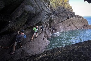
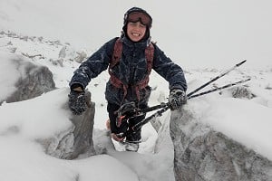
'There are a lot of ways to die here' remarked Sergiu, the expedition leader. We had just seen a family of "car sized boulders" break loose from the ice, and free fall 50m into a large supraglacial glacial lake.
The resulting sudden fragmentation of the ice and rock sent shock waves throughout the glacial lake in all directions. The glacier groaned and heaved. The ice beneath our feet felt unstable. After some minutes the glacier calmed, and we were able to continue on our way. There must be an intricate and vast subglacial system of meltwater underneath us, transporting mass from high to low altitudes. Perhaps the meltwater acts as a lubricant, enhancing the advancement of the glacier, hence blocking the trunk valley of Shimshal and leading to the formation of dangerous glacial lakes. This was always on our mind, the hypothesis we tried to prove.

© Sergiu Jiduc
Sergiu and Oliver were the 'scientists' of the KAP, an expedition to the remote Karakoram Mountains of Northern Pakistan. Along with photographer Tim Taylor and cinematographer Matthew Farrell, they spent two months in these desolate and beautiful mountains. The Karakoram is home to the snow leopard, K2 (the second highest mountain on the planet), and the largest glaciers in the world outside of the poles. These massive glaciers and their lakes were the reason for our visit.
The KAP was a mission to investigate a little known but deadly hazard unique to regions with big glaciers, GLOFs, or 'inland tsunamis' as they are known, and which occur when an ice dam containing a glacial lake breaches. The subsequent surge of water rushes downstream, destroying anything in its path. It is thought that over 80,000 people in the Karakoram are at risk from glacial lake outburst floods.
One of most badly affected regions of the Karakoram is called Shimshal Valley. This isolated place became our home for two months, whilst we assessed how the glaciers there might be affecting the likelihood of outburst floods.
 © Mathew Farrell, Flow State Photography, KAP
Getting to Shimshal
Just getting to Shimshal was hard enough. The internal flight from Islamabad to Gilgit, the closest city to Hunza and the gateway from Pakistan to China, is a temperamental affair. At the first sign of bad weather the flight is cancelled. Safe to say bad weather prevented our travel north for four days running. We were forced to drive.
The drive north from Islamabad is notorious. Whilst we were careful to avoid the Karakoram Highway (KKH), which is black listed as no-go by the British Foreign Office for security reasons, the alternatives still present a whole host of difficulties. Most of these originate from the mountainous landscape where even small amounts of rain create road-blocking landslides. One of these halted our progress for five hours, as we waited for the impressive clearance operation that kicked into action – large bulldozers came rumbling down the road and promptly began to shift industrial amounts of earth.
Having driven for two days we reached the spectacular Hunza valley. The backdrop to Hunza is Ultar Mountain (7388m) and across the valley in Nagar, the gleaming snows of Rakaposhi (7788) thrust a vertical five kilometers skywards. The many glaciers surrounding the valley have gifted the valley water for crops, and the rich green of the valley floor contrasts markedly with the browns, greys and whites of the surrounding mountains. The glaciers have even provided a historic defense to the people of Hunza. Baltit fort, which stands high upon an old glacial moraine above the valley and dates to the first century, was for centuries protected from attack to the north by a large glacier. That glacier has long since retreated into the snowy mountains from whence it came, but it serves to illustrate the significance of glaciers in defining civilization in Hunza.
 © Karakoram Anomaly Project
The great mountain explorer Eric Shipton once called Hunza valley – "The ultimate manifestation of mountain grandeur and, at 2400m above sea level, it is indeed a fairytale land, rich, fecund and of an ethereal beauty". The tiny terraced fields ripple down the mountainside, neatly arranged like fish scales, each supported on a high drystone wall. The colours change with the seasons: emerald green in the spring, orange and red in autumn. Everywhere the slender poplar trees cut strong vertical lines in the horizontal terraces and stand against the glacier-scarred rock.
In the upper end of Hunza Valley, a massive lake was standing in our way. The lake known as Ata Abad was formed due to a huge landslide that occurred on January 4, 2010. The landslide killed twenty people and blocked the flow of the Hunza River for five months. The lake flooding displaced 6,000 people from upstream villages, stranded a further 25,000, and inundated over 19 km of the Karakoram Highway. The lake reached 21 km long and over 100 metres in depth by the first week of June 2010 when it began flowing over the landslide dam, completely submerging lower Shishkat and partly flooding Gulmit.
Difficulties did not end here. After crossing Ata Abad with our 1000 kg of supplies and equipment and our 8-man team including two local assistants, a fantastic chef with experience of working in Moscow's top restaurants and extremely resourceful mountain guide, Ali Muhammed Saltoro, our journey reached yet another obstacle. The entrance into the Shimshal valley, a deeply cut and treacherous gorge had been blocked by a giant rock avalanche. Here we had to call the only available vehicles in the remote Shimshal village to come and take over the load and us from the avalanche point.

© Tim Taylor Photography, Karakoram Anomaly Project.
Shimshal Valley and Shimshal Village
Shimshal is a relatively large Wakhi-speaking village supported by vast herds of sheep, goats and yaks that are moved up and down the valley with the seasons. The valley of Shimshal was closed to visitors until 1986, after which an increasing number of adventurers braved the mountain trail through the narrow and dangerous Shimshal gorge. It was from the upper Shimshal, even as late as the 1890s, that raiders harried caravans heading to Kashmir. In 2003 a jeep road was inaugurated that finally linked Shimshal village to the KKH.

© Tim Taylor Photography, Karakoram Anomaly Project.
The road to Shimshal leaves the KKH at the snout of the Batura Glacier, 6km north of Passu. It crosses the Hunza River on a suspension bridge and then enters the narrow gorge of the lower Shimshal River; a more ominous gateway would be hard to imagine. After about an hour of negotiating a shifting, cliff-hugging jeep track and crossing a couple of daunting bridges, an experience definitely not for the faint hearted, we arrived at Dut, a reforested oasis with no permanent settlement but a few huts for shepherds and road workers. Soon after Dut the valley opens out, closes in again, and glaciers approach the road. It's hard to picture more awe-inspiring and stark scenery. Flowing off the lofty white mass of Distaghil Sar (7885m) – the 19th highest mountain in the world, Malungutti glacier descends right to the road, calving its ice into the rapidly flowing Shimshal River.
 © Mathew Farrell, Flow State Photography
Shimshal is made up of three villages: Aminabad, Shimshal and Khizarabad. Aminabad is announced by vast fields of stones hemmed in by drystone walls, and fortress-like houses of stone and mud. As one approaches Shimshal a glimpse of Adver Sar (6400m), also known as Shimshal Whitehorn can be seen. Shimshal has hydroelectricity for five months of the year (when the water isn't frozen). According to local tradition, Shimshal has been inhabited for 400 to 500 years. A charming legend tells of the first settler, Mamu Singh, the son of the wazir (prime minister) of Hunza, who fell in love with a girl from the Wakhan and defied his family by marrying her and eloping to the remote Shimshal valley to live. Shimshal was later used as a penal colony by the Mir of Hunza who exiled criminals and troublemakers to this remote valley. It was also from the hidden valley of Shimshal that the Hunzakuts raided caravans crossing the mountains from China to India, even as far as the Karakoram pass in Ladakh, 200km away. The trade route from Leh to Yarkand.
The reason why Shimshal was located in such an out-of-the-way place is because this is where the Mir (ruler) of Hunza used to send his people who were found guilty of crimes and also those who he just did not like! Shimshalis are now a proud and hardy folk. Their hospitality is legendary and the natural beauty that they inhabit makes tourists feel that perhaps the Mir sentenced them to heaven, not hell. Shimshal is the oldest of the Whaki speaking villages in Gojal. Some claim that it is an attraction for anthropologists as the only place where the culture and values of Hunza is still alive. These characteristics all make Shimshal one of the best places to visit in Hunza.
 © Mathew Farrell, Flow State Photography
C. J. Morris, 1928 – one of the first to accurately describe Shimshal referred to the valley in The Geographical Journal as follows: "The whole of this region must be one of the most desolate in the world. Everything here is grim and desolate, and the general effect of the scenery is depressing in the extreme. Even the glaciers with which this country abounds are dirty and covered with debris, and the giants of the Karakoram, but for which this country could only be described as hideous, seem to lift their heads above this scene of desolation only in disdain".
Tourism and Hospitality in Shimshal
In Pakistan, a traveller will be treated as an honored. This is not just an empty phrase, but part of the Pakistani tradition of hospitality. He or she will be invited into homes and offered endless cups of tea. The tricks is to smile and shake hand as ask polite questions about health and family – this is the Pakistani way, and if one learns a few words in Urdu, it will pleasure everyone.

© Tim Taylor Photography, Karakoram Anomaly Project.
Until 1987 the hospitality of the Shimshali people, the serenity and calmness of the valley and the rediscovery of a lost paradise were the main themes of most references to the region. These perceptions confirm the findings of most social science work on tourism – that people come to places such as Shimshal to escape from their mundane routines and to seek places of untouched nature and history. But as these tourists were escaping their routine structure, they were getting sucked into another structure often called the structure of "newness" according to which the motivation to visit somewhere new is perhaps more important than finding an escape. This is apparent in how most tourists are in a rush – many comment that they are able to stay in a place only for a short period of time. This, perhaps, reflects Leed's (1991) point that in their efforts to escape their daily routines, tourists often find themselves sucked into another routine, that of the touristic mode, that is marked by the experience of estrangement after estrangement.
In the old days when travelling conditions were harsh, Shimshalis could relate to the hardships that tourists had experienced during their journey to Shimshal so they felt naturally compelled to extend their full hospitality to them. This claim is further strengthened by the fact that Shimshal in the 1980s and 1990s was fully self-sufficient in food, so feeding extra mouths had never been a problem, unlike in many other villages in the region where food shortage is a fact of life and hence puts a practical restraint on hospitality. Moreover, hospitality was an extension of an already existing institutionalized practice in Shimshal in which they welcomed strangers into their villages and homes.

© Tim Taylor Photography, Karakoram Anomaly Project.
Getting to Base Camp
The mission to reach base camp some 15km up the valley from Shimshal village with our 1000 kilos of supplies and equipment took some serious logistics problem solving. First we had to find sufficient porters and animals available to come with us to Yukshin glacier. During this time of the year, most villagers are busy with ploughing the fields. Next we had to negotiate a fair price and weight for them each to carry. It is here that the resourcefulness and negotiation skills of our guide, Ali Saltoro, proved invaluable. Nevertheless, the agreement was by no means what we expected. Each porter decided to carry only 20kg instead of 25kg as communicated to us prior to our arrival in Pakistan, and the pay, well they basically wanted double the money.
 © Tim Taylor Photography, Karakoram Anomaly Project.
We left early the next day with our convoy of 50 porters, 10 donkeys, 2 yaks and a goat that we ironically named Rambo. The trek takes us skirting Yazghil glacier – a 33km long white beast, opening like a spanner near Shimshal river. The excruciating afternoon heat burning the desert valley, made our progress quite slow. We stopped late afternoon near the snout of Khurdopin glacier – a giant (47km long) glacier originating from the white slopes of "Snow Lake" – a high altitude glacial basin at the head of the Hispar and Biafo glaciers that is snow covered all year round. The next day we continued our journey to Yukshin glacier.

© Tim Taylor Photography, Karakoram Anomaly Project.
Mid afternoon we arrived at the glacier. In reality, what we researched on Google Earth is a large white shoulder of ice covered with a thick layer of debris. We couldn't see over it or even determine the shape of what lay ahead. Trust is another form of surrender. We trusted each other completely and laddered out onto the snow on two ropes moving like articulated pieces of a single mind. The glacier is ancient, vast, hot and reeking of history. Centuries of dust striate its powerful contours; a mass of compressed weather events, evolutions and time. Insignificant at best and entirely irrelevant, we explored this torn white carcass and were sent down its various tentacles and over bridges. We adapted to the new method of travel. And without understanding why, we were silent. This felt like an apprenticeship, or an evaluation. And then at the end of our crossing, we were invited inside this massive being.
Scattered around the terminal end of the glacier are stranded chunks of blue, exposed to the sun and disappearing. Inside the cave where it hangs from the mountain, the space is cool, intimate and quiet. There is an undeniable presence. It was like being close to another person. We listened to the glacier breathing, and dying. It was impossible not to feel sad. It was impossible not to feel elated.

© Tim Taylor Photography, Karakoram Anomaly Project.

© Sergiu Jiduc, Karakoram Anomaly Project.
A day in the field
Home is a tall moraine ridge rising sharply above the 17km long Yukshin glacier. A small creek of water sourced by a hanging serac provides life to our camp. Dishes are scrubbed with sand, socks are turned inside out to dry. Cosy is lying down on a smooth shelf of rock and watching the sun set in the impossibly clear distance. Each stage of the day sees further shedding, bringing us closer to each other and to ourselves.
A typical day in the field would start with a cold but refreshing bath in the glacial stream, flowing near to our base camp. Next we would salute our Pakistani team and sit down at the kitchen table, eagerly waiting for chef Moscow's breakfast delicatessen: cereals, powdered milk, eggs with processed cheese, jam and many chapattis. After stuffing our bellies with food, we slowly prepare our packs for another day on the glacier. Today we're doing the GNSS survey up the glacier, some 6km walking distance from base camp. After setting up the GNSS base station located on the highest point on the moraine we begin our journey through the treacherous terrain. By the time we struggle up the glacier to the equilibrium line altitude, we are sweaty, organised and free. Pack strap adjustments are sorted, weight is redistributed and we have assumed a tribal order. In all directions stretch rows of mountains empty of human traces. A giddy excitement takes hold, the internal vertigo that is the shift towards simplicity.

© Tim Taylor Photography, Karakoram Anomaly Project.
We find the 6-tagged boulders using a handheld GPS and carefully measure their position using the Trimble R10 Rover Receiver. We take great care to position and maintain the GPS above the marked sign for 6min – the time it takes for the GNSS to take 360 precise measurements and average them. Conversations stream out behind us, like prayer flags turning gently in the breeze. We walk, rest, walk, and talk. Lunch is a package of processed cheese called "happy cow", several chapattis and a chocolate bar, paired with crystal clear glacial creek water. Fieldwork is a daily activity, whether geomorphic mapping, GPS survey or a well deserved rest day.
Day after day, we watch each footstep and monitor our balance. The relentless focus drills through everything to what really matters: the quiet, the sun, moving with confidence that we did not have yesterday. Yet the people we love in our other lives float amongst us, shimmers in the air or a wave of heat from the valley bottom.

© Sergiu Jiduc
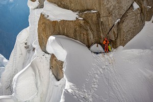
Adventurous Activities: Mountaineering – Yukshin Gardan Sar
The rope is fully tensed. Matthew must have fallen in another crevasse. I hold my belay system diligently and kneel down in the soft fresh snow to better control the forces that are pulling me across the edge into a deep abyss. All around us the blizzard has completely engulfed the giant, jagged peaks of Shimshal valley, many of them over 7500m high. Visibility has been reduced to less than 20 meters. I feel so weak that I can barely manoeuvre the rope to rescue Matthew out of the ice tomb. The last 2 days have been particularly hard, as we had no chance to make water and prepare water. If it wasn't for the towering sercacs marking the crevasse edges, we would have been long dead. Where are we you may ask? It must be hell...
In the summer of 2015, as part of a multidisciplinary project entitled the Karakoram Anomaly Project, Mathew Farrell and Sergiu Jiduc attempted to climb a remote and poorly explored 7000m+ peak in the Hispar – Muztagh Group, a sub range of the mighty Karakorum Range of Pakistan. Known as Yukshin Gardan Sar, the mountain measures 7530m above sea level and lies about 15 km northeast of Khunyang Chhish (7852m) and 5 km northwest of Kanjut Sar (7760m), - two other giants of the of this planet, barely missing the membership of the 8000m+ club. Yukshin Gardan Sar is flanked on the northwest by the Yazghil Glacier and on the northeast by the Yukshin Gardan Glacier, which both drain into the notorious Shimshal River.
Yukshin Garden Sar is a technically difficult mountain that had not been climbed since 1986. With only three small teams attempting their luck on the mountain it is fair to say that the peak is poorly documented in literature. In fact most peaks of Shimshal valley, have neither been climbed nor properly described. The route via the south face of Yukshin Gardan Sar that we attempted had never been climbed before and no information whatsoever was available about this face. Therefore our risk assessment was primarily based on Google Earth Maps and on site observations. It is worth mentioning that the sense of perspective in the Karakoram can change dramatically – the shear size of glacier features here is enormous and beyond anything we have ever seen.
 © Mathew Farrell, Flow State Photography
Having already established a base camp on the western lateral moraine of Yukshin glacier, the next important leg of the mountaineering quest was to set up an advanced base camp (ABC) from which we could attempt several ascents up the extremely fragmented ice fall that was separating us from the col. The terrain was very complex, riddled with hanging seracs and menacing crevasses, but so remote as to make any hope of help impossible. No wonder no one has ever tried to climb this route. After establishing ABC at 4100m under the icefall and equipping it with gas, food and climbing kit, Mat and I decided to make an attempt and so packed with supplies, camping gear and warm clothes we began climbing the steep maze of towering seracs and bottomless crevasses. Often we would look back on the slope that we had already traversed; they appeared impassable. So could tomorrow, until tomorrow turns into yesterday. Instead of reaching our proposed camp I in one day as estimated it took us 2 full days of climbing unstable crevassed terrain, jumping from and climbing giant seracs the size of buildings. This was the icefall climb (from advanced base camp at 4100m to camp I at 5150m), by far the most dangerous section of the whole climb. When you venture into these unchartered landscapes, you have to surrender and just put your head down. It took two days to work through that maze of crevasses; it felt that I could get through anything.
 © Mathew Farrell, Flow State Photography
In addition to the objective hazard posed by the nature of the glacier, the changing and unpredictable weather conditions and the extreme cold were not on our side especially in the high camps. Every big mountain constructs its own microclimate, which can be very unpredictable. Therefore, weather forecasts for big and remote mountains, are only 50% accurate, making decision-making quite difficult. Experience, and on-site observations as well as intuition play a major role in deciding whether to push forward or abandon a climb. We tried twice to reach the summit from camp 3 at 6400m. However, our contingency time ran out and so did our supplies. Two failed summit attempts due to the extreme cold (-35 degrees C) and high avalanche risk resulted in an overconsumption of our supplies. We decided to get off the mountain as soon as possible. On day 10 on the mountain we were in camp 2 (5800m) and here we realised that our gas was used up. This marked the moment where our situation became very problematic. In addition, all around us the mountain was strongly expressing its presence with frequent rock and ice avalanches blasting from the rupture of hanging ice seracs and running down the south face barely missing us. To make matters worse the blizzard, which started during our summit attempts, was omnipresent.
 © Mathew Farrell, Flow State Photography
Not having enough gas to melt snow in order to make water and cook food was a huge problem especially since we were a long way from safety (2000m level difference to be precise). In addition we were experiencing whiteout conditions, and feeling exhausted and lost. The survival mission back to advance base camp took us 3 days and involved no water and food whatsoever, falling in dozens of crevasses, and dragging ourselves through fresh deep snow on possibly the worst glacier we have ever been on in our lives.
 © Mathew Farrell, Flow State Photography
We even tried to call for a rescue helicopter from the military, but these issues take time, a commodity we could not afford at that time. However, in the end our strong motivation, good teamwork and luck pushed us to safety. We descended safely to ABC without being rescued by a helicopter. This was due to an inspired decision to cross the icefall laterally and enter the north face of the mountain where we found water and abseiled in a steep and gigantic gully using some 40+ rappels.
Fatigue is a moment of surrender. We are more aware of our surroundings; we feel rather than think and this leads into our first discovery, an icy couloir, carved into the vast, limestone north face of the mountain. Inside this gully, a voluptuous world made of calcium carbonate and hundreds of million years old little fossils. Long and sinuous, the gully has holes in its fabric and a white snow and blue ice cover. In its details, we see beauty that is the result of consequence. Everyone should be so lucky to witness such grace.
My quest for beautiful lines up mountains where I find peace and clarity through intense mental focus where I can tune everything else out and just focus on that next step will continue. Risks are always calculated but there are moments when it just doesn't feel right. Having a passion can be both a great uplifting thing and a curse.
Lewin's equation described human behaviour as a function of personality plus environment. It was the first theory of understanding human nature that gave importance to a person's momentary situation, rather than relying entirely on the past. As humans, we have all encountered turning points, moments of decision-making that will affect the course of our lives, whether we recognize it in the moment or not. To be steadfast is to have known the weakest part of yourself and moved through that territory into an unwavering commitment. No one here is rough or raw. They are unshakable, tightly bound, like industrial cable that will not fray, meeting whatever happens with muscle and guts, humility and grit.

© Tim Taylor Photography, Karakoram Anomaly Project.
Find out more about the Karakoram Anomaly Project on their website.
Visit the KAP Facebook Page.
Visit Sergiu's website.
UKC Articles and Gear Reviews by Natalie Berry UKC
- SKILLS: Top Tips for Learning to Sport Climb Outdoors 22 Apr
- INTERVIEW: Albert Ok - The Speed Climbing Coach with a Global Athlete Team 17 Apr
- SKILLS: Top 10 Tips for Making the Move from Indoor to Outdoor Bouldering 24 Jan
- ARTICLE: International Mountain Day 2023 - Mountains & Climate Science at COP28 11 Dec, 2023
- ARTICLE: Did Downclimbing Apes help Evolve our Ultra-Mobile Human Arms? 5 Dec, 2023
- ARTICLE: Dàna - Scotland's Wild Places: Scottish Climbing on the BBC 10 Nov, 2023
- INTERVIEW: Loki's Mischief: Leo Houlding on his Return to Mount Asgard 23 Oct, 2023
- INTERVIEW: BMC CEO Paul Davies on GB Climbing 24 Aug, 2023
- ARTICLE: Paris 2024 Olympic Games: Sport Climbing Qualification and Scoring Explainer 26 Jul, 2023
- INTERVIEW: Malcolm Bass on Life after Stroke 8 Jun, 2023


Comments