Climbs 24
Rocktype Granite
Altitude 6233m a.s.l
Faces all
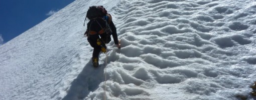
Nearing the Summit Ridge, Muzkol Pamir, Tajikistan © jonathandavey
Crag features
Rock type may be more accurately described as a mixture of granite, crumbly rubbish and ice. The first parties to visit the area (during the late Soviet era) visited the granite faces of Bitkaya and Chatagai following reports from geologists. Spot heights given are from Soviet map (see upload) unless otherwise stated. Where no spot height is given on Soviet map, I have used the spot height from google earth. Comparison of spot heights on Soviet map and google earth for those peaks whose height is marked on the Soviet map suggests that google earth mapping for this region is reasonably accurate.
Email me at john.proctor1982@gmail.com if you would like a high-res copy of the Soviet map with annotations. In my experience of Soviet maps, the surveying is detailed and accurate and this map is no exception. I have added the GPS and Google earth-compatible WGS84 datum to the Soviet map (red grid lines).
Route descriptions often refer the reader to articles in the American Alpine Journal. These can be accessed free online here:
http://aaj.americanalpineclub.org/
Though the search facility does require some persistence. About half the routes climbed in this range were climbed as part of a series of commercial expeditions in the mid-late 1990s by the company EWP. Various pages on EWP website (http://www.ewpnet.com/) describe these climbs in varying levels of detail, and also routes on a few minor peaks which I have omitted from the maps and database for clarity - Shattered Point, Ximena, Grud, 4 Nations Peak, Pt Theresa and Pt Marina.
Grades, where given, are usually just a guess. It is better to read the route descriptions and view the maps + photographs to get a feel for what the routes will be like. If you need to be given an adjective grade before attempting a route then the Muzkol range is probably not a suitable destination for you.
Some accounts of ascents in this range are published only in Russian, and there is also some confusion regarding naming, with some peaks having more than one name, different spellings of the same name in use, and even one name (Zartosh) that is used for 2 peaks in the range! For some good recent photos it is worth taking a look at an account of a Russian expedition in summer 2012:
http://www.risk.ru/users/sromanenkov/195534/
Approach notes
Most parties access the range from the north-east. The nearest town, Murgab, can be accessed in 2 days driving from Dushanbe (capital of Tajikistan) or 1 day driving from Osh (in south-west Kyrgyzstan). Dushanbe, however, has more flights and probably more options for purchasing supplies.
The range is a very long way from anywhere. A quick and effective rescue if you get into trouble is unlikely.
| There are no comments from visitors to this crag. |
Climbs at this crag
| Name | Grade | Stars | Type | Logs | Partner Ascents |
|---|
These climbs you have climbed by seconding or top-roping.
These climbs you have Dogged.
These climbs you Did not Finish.
Climbs are waiting to be checked by a crag moderator, and may not be accurate. Climbs can't be verified by a crag moderator, and they need more information to confirm it. Climbs are no longer climbable.
Moderators Updates to this page are checked by a UKC volunteer JdotP