Climbs 44
Rocktype Limestone
Altitude 307m a.s.l
Faces SW
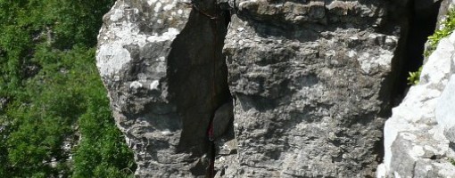
Evel Knievel (VS 5a) © Simon Caldwell
Crag features
The scar is about half a mile long with an open aspect. Be wary of the grades as past access difficulties have hindered systematic checks. Care should be taken of loose rocks and holds on some routes.
Approach notes
Follow the minor road NE from Marske (Cordilleras Lane)uphill onto Markse Moor. About three-quaters of a mile past a cattle grid a bridle way leaves the road. Follow this and where it descends towards Marske Bridge then leave it and head up to the top of the scar keeping to the right of a wall. About 20 minutes.
The far left of the crag (routes 32 to 42 in the old guide) are on CROW access land. Climbing is only allowed on the remainder from 1st Feb to 31st July.
Access Advice
For many years the landowner did not allow public access, however part of the crag is now included in Open Access Land - routes 32 to 42 in the guide. There is currently permission to climb on other parts of the crag (which arguably contain the best routes ie Nos 1 to 31) but only between 1st February and 31st July.
Seasonal Restrictions
Dates: 1 August to 31 January
Reason: Nesting Birds
Routes 1 to 31 in guidebook- No climbing between 1st August to 31st January due to ground nesting birds and shooting.
| Ooops! My flags don't show up for other users of Google Earth. However, Humes Gully descent is clearly visible close to Moomintroll Pinnacle. Moving N/NW along the edge, the big chimneys (Blue Funnel, Yo-Yo and Chockstone) are prominent indentations parallel to the line of the edge. johnjb - 19/Aug/11 |
|
| Difficult to locate routes without a map. I have marked up some major features on Google Earth.
54�24'47.88" N 1�51'11.00" W
The easiest descent route is Humes Gully at the right hand side. johnjb - 18/Aug/11 |
Climbs at this crag
| Name | Grade | Stars | Type | Logs | Partner Ascents |
|---|
These climbs you have climbed by seconding or top-roping.
These climbs you have Dogged.
These climbs you Did not Finish.
Climbs are waiting to be checked by a crag moderator, and may not be accurate. Climbs can't be verified by a crag moderator, and they need more information to confirm it. Climbs are no longer climbable.
Moderators Updates to this page are checked by a UKC volunteer Simon Caldwell