Climbs 11
Rocktype Andesite
Altitude 6962m a.s.l
Faces all
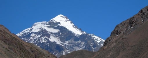
Aconcagua Vacas Approach © Rich Kay
Crag features
Aconcagua is the highest mountain in South America, in the western hemisphere, and in the southern hemisphere, too. No other peak on earth, except Mount Everest, is further away from a higher peak - you have to travel over 10,250 miles to the Hindu Kush Mountains of Pakistan to find higher ground when traveling from Aconcagua.
There have been occasional noises made by the Argentines and others that Aconcagua might be over 7000m high, but it seems that the consensus is that it falls just short, leaving all the world's 7000m peaks in central Asia. An Italian expedition in 2001 with super-accurate GPS equipment has fixed the peak's elevation at 6961.83 meters.
The mountain is geologically complex, and while many of the rocks that form it are volcanic, the general feeling seems to be that Aconcagua is not an eroded, long-dormant volcano, as one might suppose. That leaves Ojos del Salado, in the Puna de Atacama well north of Aconcagua, as the world's highest volcano.
The peak is located 15 km east of the main crest of the Andes, entirely in Argentina. This is the dry side of the Andes, so, despite its height, Aconcagua is not particularly icy or snowy. The standard routes up the mountain involve no glacier travel. The area is not as arid as the bone-dry Puna de Atacama, but the glaciation is less than in the Andean peaks of Peru and Patagonia
Approach notes
Leaving Plaza de Mulas you follow the route indicated in the accompanying chart. It is advisable to make a first stage and set up a base camp at the top part of the "Portezuelo del Manso" (5,200m). It is a good practice to stay at the base camp for a couple of days for a proper acclimatation. The area is characterized by a great number of rocks which allow for well-protected camps. Depending on snowfall intensity during the winter time, in some seasons there may form a small lake which provides the necessary water supply for expeditions. The "Antartida Argentina" refuge (5,500m) is no longer used by climbers since it now lies way off the route.
From "Portezuelo del Manso" or Camp 1, climbing gently up easy alluvium paths, you reach refuges "Plantamura", "Libertad" and "Berlin" (6,000m) . At this altitude many expedition also stay for a couple of days for acclimatisation. From this point two alternative routes are possible: the first one is to scale all the way up to the summit, an exhausting climb in itself. The second one is to reach refuge "Independencia" (6,500m) and from there, on the following day, go up to the top. The first alternative is the most usual, but you are very likely to be caught by the darkness of night on the way down. Whereas the second one, though implying shorter journeys, has the disadvantage that it may become very rough to stay overnight at such altitudes, matters being aggravated by the fact that the refuge is half in ruins.
In any case, and due to the numerous expeditions trying to reach the top week after week, the use of tents is more than necessary, since all the refuges are like small bivouacs with capacity for 3 or 4 people. Coming down there is a natural predisposition to follow the route of the Gran Acarreo, but this way will invariably deviate you from the refuges. There is no natural protection against eventual storms and bad weather in this route. If there is a tempest, it is suicidal to go down following the way of the Gran Acarreo, hoping you can do it more rapidly. We know by experience that there is no natural defense where you can wait under protection until fury of the storm has passed. Both ascending and descending it is always prudent to follow the rock of the North West where you will find the refuges.
If physical conditions are good in the ascension, you can calculate 20-40% less time for the descent. If you are very tired after the ascension, this calculation is not helpful because at these heights recovery is not possible. So you need more Or less the same time for coming down as you used for ascent. This northern route does not present technical difficulties, but you must not forget storms of an unbelievale force and altitude "puna". You must observe all the serious rules of mountain safety. Otherwise, any mistake can be fatal and form of suicide.
| There are no comments from visitors to this crag. |
Climbs at this crag
| Name | Grade | Stars | Type | Logs | Partner Ascents |
|---|
These climbs you have climbed by seconding or top-roping.
These climbs you have Dogged.
These climbs you Did not Finish.
Climbs are waiting to be checked by a crag moderator, and may not be accurate. Climbs can't be verified by a crag moderator, and they need more information to confirm it. Climbs are no longer climbable.
Moderators Updates to this page are checked by a UKC volunteer tehmarks