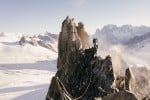
Rockfax Description
320m. Another scrambling route which is slightly harder than its neighbours. The climbing is never sustained and is well-protected with bolts. It is a bit green in places.
1) 4a. Climb the slab next to the double-ended tree, move left and then climb another slab (4a) to much easier terrain.
2) 4a. 50m of easy grassy ground takes you to a cairn. From here, climb the 8m red slab on the left to reach the foot of a broken looking black and white slab which steepens after 15m. Climb this and traverse left 5m to a large grassy ledge (3c). Climb slabs at the back of the ledge for 25m, ending with a steep step (4a) to reach the open gully/scoop of Voie Caline.
3) The next two bolts are hard to spot but are 20m up on a short wall, directly below a water-worn runnel on the right.
4) From the foot of the runnel, step left and climb the blunt arête and then continue up slabs and short walls, always drifting right if in doubt. There is a mixture of new bolts and rusty old ones but they are there if you look. Often the route goes further right than feels logical but stick with it.
5) After 150m of easy, grassy ground, a 20m traverse right takes you to a magnificent steep 30m slab (4a), then a final shorter slab and a cairn mark the end of the route. It is easier to bushwhack for 50m leftwards and join Voie Caline descent path than trying to go direct to the Buvette through the trees.
3) The next two bolts are hard to spot but are 20m up on a short wall, directly below a water-worn runnel on the right.
4) From the foot of the runnel, step left and climb the blunt arête and then continue up slabs and short walls, always drifting right if in doubt. There is a mixture of new bolts and rusty old ones but they are there if you look. Often the route goes further right than feels logical but stick with it.
5) After 150m of easy, grassy ground, a 20m traverse right takes you to a magnificent steep 30m slab (4a), then a final shorter slab and a cairn mark the end of the route. It is easier to bushwhack for 50m leftwards and join Voie Caline descent path than trying to go direct to the Buvette through the trees. © Rockfax
UKC Logbook Description
An easy climbing/scrambling route that finishes near the Buvette des Mottets. Slightly harder than the neighbouring Voie Caline and Via Corda Alpina, though the climbing is never sustained and is well-protected with bolts. A bit green and lichen-covered in places
Ticklists
Chamonix Valley "Easy" Multipitches
Feedback
| User | Date | Notes | ||
|---|---|---|---|---|
| Smythson | 7 Jul, 2023 |
Show βeta
βeta: Parts of the route in are restricted due to logging until 21st July. Still easy enough to start (just walk NW towards a footbridge) Coming down trickier due to closures, I ended being diverted to the Montenvers car park which made a long walk back in 32C heat! Work was stopped in the afternoon so jump the cordon tape at your discretion... | βeta? | |
|
Show beta
βeta: Parts of the route in are restricted due to logging until 21st July. Still easy enough to start (just walk NW towards a footbridge) Coming down trickier due to closures, I ended being diverted to the Montenvers car park which made a long walk back in 32C heat! Work was stopped in the afternoon so jump the cordon tape at your discretion... |
||||
| Webster | 30 Sep, 2019 |
Show βeta
βeta: finding the start is pretty hard despite the bent over tree. it starts pretty much directly behind it (looking uphill) not 5m down hill of it. there is a wooden sign on a tree behind it with the names of the routes written in pen and with arrows, but it is hard to spot and impossible to read without clambering up to it. also ignore the above persons feedback, i have no idea what they are on about! if you hit the steps and cables you are on voie caline instead. | βeta? | |
|
Show beta
βeta: finding the start is pretty hard despite the bent over tree. it starts pretty much directly behind it (looking uphill) not 5m down hill of it. there is a wooden sign on a tree behind it with the names of the routes written in pen and with arrows, but it is hard to spot and impossible to read without clambering up to it. also ignore the above persons feedback, i have no idea what they are on about! if you hit the steps and cables you are on voie caline instead. |
||||
| Johnathan | 17 Aug, 2019 |
Show βeta
βeta: Ignore all the old rusty bolts. There are quite a few in places. | βeta? | |
|
Show beta
βeta: Ignore all the old rusty bolts. There are quite a few in places. |
||||
| 67hours | 24 Jun, 2019 |
Show βeta
βeta: To find the start, continue on the path past the sign on the tree to the right with the names of this route and the adjacent. After about 80m you reach a large rockfall, turn right up the track immediately before this. This track climbs up the metal steps and cables for some distance, until the entrance is on the right, next to a sign and shortly before the first metal ladder (which is not part of the approach or route). | βeta? | |
|
Show beta
βeta: To find the start, continue on the path past the sign on the tree to the right with the names of this route and the adjacent. After about 80m you reach a large rockfall, turn right up the track immediately before this. This track climbs up the metal steps and cables for some distance, until the entrance is on the right, next to a sign and shortly before the first metal ladder (which is not part of the approach or route). |
||||
Logged Ascents
Guidebooks for Les Mottets
Not all climbs appear in all guidebooks

Please Login to view more details on the logged ascents
Aiguille d'Entrèves Traverse
Grade: AD- 4c ***
(Aiguille d'Entrèves)