Climbs 31
Rocktype Schist
Altitude 400m a.s.l
Faces all
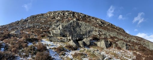
Creagan Caise Hill Boulders © C.MacLeod
Crag features
Glen Isla has a small selection of established schist boulders in a picturesque location but development in the area is ongoing due to further potential. The outlook is particularly beautiful with views north towards Glas Maol and south to Mount Blair while overlooking River Isla. Additionally, the area gets sun from mid-morning till dusk so combining this with the vista and location, makes it a very idyllic climbing spot.
Currently, the developed boulders are on the east side of River Isla lying on the upper southwestern slopes of Badandun Hill, and on the west side of River Isla on the upper eastern slopes of Creagan Caise Hill between the villages of Forter and Auchaven. The boulders vary in height from approx. 2-5m with grades (so far) ranging from f2-6c, but f7’s and harder projects are envisioned, so this is a venue for all abilities and perhaps even adventurous families. A bouldering mat and brush is recommended due to the mixed nature of landings and recent cleaning. Also, the short hike up the slopes crosses small sections of bogland and although dry in spring, perhaps boots / wellies and tarpaulin may be sensible for autumn and winter or if there has been any heavy rain.
Overall, the area is still very new and in development, so be careful when trying established or new boulder problems as everything needs a proper clean and there could be loose rock. Finally, all grades are just rough estimates for now until they see more repeats and become established.
Approach notes
For the Badandun Hill boulders follow the B951 from Kirriemuir or the B954 from Alyth to then join the B951 near Dykends. After the Bridge of Brewlands turn right towards Folda and drive through the village and then park in an obvious bay on the right - next to sign-posts for The Cateran Trail and Glen Prosen - just before reaching a sharp left turn over a stone bridge that takes you into Forter. From Braemar via Glenshee follow the A93 and then turn left near Lair onto the B951, follow this road and then turn left towards Forter Castle, drive through Forter and turn right towards Folda crossing the River Isla over the stone bridge and park on the left in the obvious bay (as above).Parking Coordinates:
56°46'02.3"N 3°19'51.9"W
Walk north towards the bridge passing the sign about ‘The Glen Isla Giants’ and go through the large wooden gate on the corner of the road. Walk up the track past the cows, then continue for a short while until another wooden gate is reached. Pass through this and then cross over a small stream that cuts across the track next to the woodland on the left, then continue until a pair of old rusty posts are reached. From here the boulders and crag are visible to the right on the upper slopes, so hike uphill trending towards Smoutachanty’s Boulder which is the largest on the hillside. Once you arrive, Fiscal’s Face, Badandun’s Tooth and Òrla’s Stone are viewable from here and are situated directly uphill looking East. The walk takes approximately 30 minutes overall.
Smoutachanty’s Boulder Coordinates:
56°46'59.6"N 3°19'16.4"W
For the Creagan Caise Hill boulders follow the same directions as above (if coming from Kirriemuir or Alyth) but continue on the B951 and turn right towards Forter Castle, then drive through Forter keeping left at a fork in the road and head north towards Auchavan. Drive for approx. 2.5 miles - passing three small areas of woodland on the left and a phone box near a group of houses on the right - until a Cairngorms National Park sign on a small stone is reached, just after the third woodland is passed. Park courteously anywhere in this area or use the small car park bay near the phone box. From Braemar via Glenshee follow the same directions as before, but turn left towards Auchavan after driving through Forter and park as above.
Parking Coordinates:
56°48'12.0"N 3°19'40.9"W
From the parking, walk to the Cairngorms National Park sign, go through the gap in the wall and into the field, then follow the drystone dyke and old rusty wire fence uphill heading west, until Ossian’s Stone comes into view. It is the largest boulder that is reached first and it is on the left side of the wall. From here, it is possible to see some of the other boulders (Selkie Slab, Temora’s Cave, Celtic Block, The Warrior, etc.) but use the coordinates provided if need be or just enjoy exploring the area. The walk takes approximately 15 minutes from the Cairngorms sign.
Ossian’s Stone Coordinates:
56°48'14.2"N 3°20'07.9"W
No Access Issues
Access to Badandun Hill boulders is via a cow and sheep field so stay on the main track, walk calmly passed the animals and always close the gates properly while passing through. Access to Creagan Caise Hill boulders is via another field but there are no animals and an opening in the stone wall makes access easier. Nevertheless, the glen is peaceful and beautiful so make sure to leave no trace.
| There are no comments from visitors to this crag. |
Climbs at this crag
| Name | Grade | Stars | Type | Logs | Partner Ascents |
|---|
These climbs you have climbed by seconding or top-roping.
These climbs you have Dogged.
These climbs you Did not Finish.
Climbs are waiting to be checked by a crag moderator, and may not be accurate. Climbs can't be verified by a crag moderator, and they need more information to confirm it. Climbs are no longer climbable.
Moderators Updates to this page are checked by UKC volunteers C.MacLeod and Craig Thorburn