Climbs 8
Rocktype Sandstone (hard)
Altitude 141m a.s.l
Faces NW
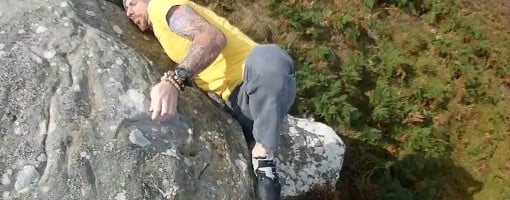
The rockover topout on Dance Kimmernder. © Andy Cowley
Crag features
A NW facing cluster of 3 boulders with the majority of problems focused around the steeply overhanging Kimmernder block.
Great for Spring and Summer months but not ideal after heavy rain or during the winter.
Approach and boulder locations are given in What3words.
Boulder locations are found by hitting 'i' for the given boulder.
Approach notes
Approaching from either end of the moor is roughly the same time of about 20-30 minutes on a good path which crosses over the moor. There is no established path to the crag but it is visible and only a short distance (330m to the first bloc) off the main path.
Follow the parking and approach notes for Beanley or Hunterheugh. I have copied the notes from both crags below.
Kimmer Crag is located more or less in the centre of the moor. From either end of the moor you will approach a gated fence and you can see the crag from here.
Fence and gate What3words location: placidly.sizzled.sheepish
From here the easiest path to Kimmer is the margine between the heather and grass tussocks. What3words location: fork.retract.squirts.
Beanley
Head North on the A697 towards Powburn. Make a right turn about a mile before Powburn on Playwell Road (what3words - thundered.goodness.spades).
Follow this road to a crossroad and go straight over. Continue for about 1½ miles to an oblique ‘T’ junction. Turn right and after a few hundred metres park on the right just past a gate and style (what3words - talking.absorbing.sprain). There’s enough space here for about 3 or 4 cars. Please be considerate and not block the gate.
Pass through the gate and follow the trail onto the moor. Continue over 3 rises to a stone built structure marked with a gas pipeline marker plate on top (Image left).
(what3words-covenants.shapes.adopters).
Turn left off the trail heading ?90° East. 30m off the trail you will see a pile of stones. Fromhere you can see the Pinnacle bloc. There is no established or defined track from here.
Hunterheugh
Turn east at the Glanton/Bolton crossroads on the A697 and go straight on for 4.5 miles to roadside parking at East Bolton farm. Take the footpath over the cattle grid and follow the track round the edge of two fields and at the bottom of the hill go straight on across a bridge over Titlington Burn. Follow the track up to the col where it swings right down towards Kimmer Lough. Go straight up the hill on the left across the rocks to a hurdle on the fence. Trend diagonally right across the heather for a couple of hundred metres, crossing a track, until you drop down onto a flat moss with the crag visible on the left. Follow the edge of this moss to the crag - a path soon appears.
The above approach can be very arduous in summer due to deep heather and head high bracken. Take advantage of any existing quad bike tracks, even if they take a less direct route. You could consider using the bridleway from near Craigs House, but this means crossing the ford or stepping stones at 117 186 and then walking across the bog west of Kimmer Lough.
No Access Issues
No access issues
| There are no comments from visitors to this crag. |
Climbs at this crag
| Name | Grade | Stars | Type | Logs | Partner Ascents |
|---|
These climbs you have climbed by seconding or top-roping.
These climbs you have Dogged.
These climbs you Did not Finish.
Climbs are waiting to be checked by a crag moderator, and may not be accurate. Climbs can't be verified by a crag moderator, and they need more information to confirm it. Climbs are no longer climbable.
Moderators Updates to this page are checked by a UKC volunteer TallAndyC