Climbs 2
Rocktype Shale
Altitude 5783m a.s.l
Faces all
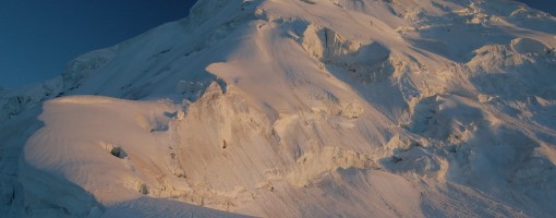
Sunset over Haighutum East's summit from our high bivi at around 5100m © Lee Harrison
Crag features
Haigutum East is a minor snow peak on the south side of the Hispar Glacier, the fifth largest glacier in Pakistan. The peak forms part of the beautiful Bal Chhish range which is a dividing marker between the counties of Nagar and Baltistan. ‘Haigutum’ refers to the grazing area further east and is the last pasture on the southern side of Hispar. Despite Haigutum East’s modest height it is an interesting, challenging peak to climb in a stunning part of Pakistan’s Karakoram. The peak would make a great introduction to the mountains of Pakistan for those with suitable climbing experience looking for a mid-grade route. It may however be problematic for inexperienced climbers due to route finding difficulties through numerous seracs and crevasses. It would also be a good choice for acclimatisation for for higher peaks.
Haigutum East is a short trek from Snow Lake, one of the most uniquely beautiful spots in Northern Pakistan. The trek to base camp is also a memorable one skirting the southern faces of the Hispar Muztagh which contains some of the most impressive peaks in the Northern Areas such as Kunyang Chhish, Trivor and Pumari Chhish. The Bal Chhish peaks along the southern side are also very dramatic. In my opinion the Hispar glacier is more inspiring than even the Baltoro glacier.
To the best of my knowledge the successful summit by me (Lee Harrison) and Peter Thompson was a first. We summited via a northern route from the Hispar Glacier in an Alpine style climb in two days making a high bivi at 5150m on route. The route is described here and the trip report is available here. No previous attempts have been made to the best of my knowledge and the south face remains unclimbed. This can be climbed from the Kero Lungma or Hucho Aichori valleys which extend north from where the Chogo Lungma glacier commences.
Approach notes
From either Karimabad or Aliabad in Hunza first arrange a Jeep to the village of Nagar and then arrange a further one to the village of Hispar at the western end of the Hispar glacier. It is not possible to take a Jeep from Hunza directly to Hispar unless to driver is from Nagar as the road beyond Nagar is privately owned and only local Nagar drivers are allowed to use it. This unfortunately will put you in a poor bargaining position. Since there is no public transport between the villages having arranged a fee for your ‘special hire’ half the village will likely to join you for the journey without contributing to the fair. Public transport from Aliabad to Nagar leaves regularly as soon as vehicles fill up. They are likely to charge a little extra if you are carrying an expedition load on the roof. The road to Hispar sometimes blocks after rain and you may need to arrange porters on route, such as the village of Huru, as we had to.
A base camp can be reached along the northern side of the Hispar Glacier in around three days, give or take a day, depending on your pace, from the village of Hispar. If you have five or more porters then a guide is compulsory according to village rules (but not government rules). Hispar porters unfortunately do not have a reputation for being the most reliable so a guide may not be such a bad idea for this trek in. Porters also want more money per stage than Balti porters who often cross Snow Lake east to west. They want Rs450 per stage including wapasi (so Rs300in effect). Wapasi is what you pay to the porter to return to where the trek began if it has finished elsewhere. For every stage half a stage is paid in Wapasi. We paid 9 stages from Hispar to our base camp on the north side of the Hispar glacier beneath the peak of Hispar Sar. Porter rates may seem high to those who have previously visited Pakistan but rates have risen significanty in the last couple of years across all the Northern Areas. I personally had minimal problems with our porters and found them to be a very amiable lot. Only problem was that they nicked our abseil tat meaning that we couldn't try a nearby peak! (Ok, that's quite a big problem) They also seemed to be attracted to campsites with no water!
The trek along Hispar is a memorable one, even if you have spent a lot of time in Pakistan before. Whereas much of the Northern areas consist of arid valleys capped with white peaks, the north side of the Hispar glacier is lined with numerous meadows and great camping spots. The trek involves virtually no trekking on the Hispar glacier and follows ablation valleys for the majority of the way. From Hispar village the trail descends to the Hispar River where it crosses a bridge to its true left bank. A short distance further a small river that runs through a shallow gorge needs to be crossed. This can be problematic if you attempt it in the afternoon as I found out! Three glaciers need to be crossed on route. These are the Kunyang, Pumari Chhish and Jutmo glaciers in that order. The Kunyang glacier is the easiest to cross however the path descending on to the western side of the glacier is becoming particularly desperate. There are awesome views of Bularung Sar (7200m), Trivor (7720m) and the mighty Kunyang Chhish massif at the northern end of the glacier.
Beyond the Kunyang glacier the landscape becomes less arid with numerous pastures. The Pumari Chhish glacier is easy to cross and also has stunning views north to Kunyang Chhish East, one of the most intimidating mixed rock faces that I have seen anywhere. The Jutmo Glacier involves the longest crossing taking approximately two hours. Again there are memorable views north to Pumari Chhish peaks. Routes across the glaciers are marked by cairns but porters know the way anyway. The only place where the route descends on to the Hispar glacier is a short stretch between the Pumari Chhish and Jutmo glaciers. Here a ravine full of loose rock needs to be descended to the glacier. A short distance further east the steep path climbs back off the glacier.
Crossing the Hispar Glacier to reach Haigutum East on the south side of the mountain requires patience. Most of the glacier is covered in loose rock however there is a broad central strip of white ice with a network of ribs and streams. Finding an appropriate route to gaining and exit this central strip may time time. In 2006 a large stream ran along the north side of the white glacial strip however it could be crossed at narrow points via large rocks that bridging the gap. You may even want to don crampons in order to take a more direct line through this central part.
For those wishing to also make an extended trek it is possible to trek up the Biafo glacier to snow lake, cross over the Hispar La and then descend to base camp taking around 8 days to do so. Transport will need to be arranged from Skardu or Shigar to Askole (same starting point for the Baltoro glacier trek).
Haigutum East can also be easily reached from the south although I have not personally done so myself. From Skardu or Shigar a Jeep can be arranged to the village of Arandu from where it is approximately a three day trek up the Kero Lungma valley which extends north from the start of the Chogo Lungma glacier. A more adventurous way to reach the southern aspect of the Bal Chhish would be to trek along the Hispar Glacier, cross the Nishik La (around 5200m at a guess) (La = Pass in local Balti language) then descend down the Kero Lungma glacier. This route looks perfectly feasible and you will probably be one of the few people to have crossed the pass.
| There are no comments from visitors to this crag. |
Climbs at this crag
| Name | Grade | Stars | Type | Logs | Partner Ascents |
|---|
These climbs you have climbed by seconding or top-roping.
These climbs you have Dogged.
These climbs you Did not Finish.
Climbs are waiting to be checked by a crag moderator, and may not be accurate. Climbs can't be verified by a crag moderator, and they need more information to confirm it. Climbs are no longer climbable.
Moderators Updates to this page are checked by a UKC volunteer Lee Harrison