


Over the last few days the UKC development team has been putting the finishing touches to a few new features, most of which relate to our Logbooks and Crag Pages. Here's a run down of the changes made.


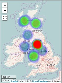
Another addition to the site is the Mountain Conditions Page. This was actually developed last year and publicised on the forums, however other work took over and it is only now we have got round to finishing it off. Much like our popular Winter Conditions Page, it features of heatmap of where things have been climbed, plus a variety of other filters including time-frame of ascents, location, and elevation.
Just in case mountains aren't your thing we've added further functionality to sea cliffs too, with the addition of the tide times + tidal range on each crag page. Here's a couple of screen shots from two very different tidal ranges: the whopping on in/around Pembroke and the relatively minor one of the Mediteranean.


Finally, and this has been on there for a while, but we've partnered up with the BMC to show live access information from the RAD (Regional Access Database) so people are clued up with all the latest access informaiton before they leave for the crag.


Comments