


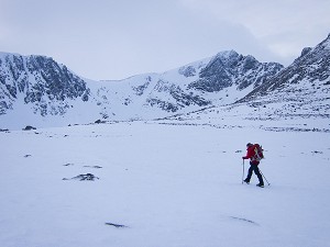
A prototype drone service that can extend airborne 4G and 5G mobile connectivity to mountain areas lacking conventional network coverage is undergoing trials in Snowdonia. The technology, being developed with Virgin Media O2 and the Llanbedr-based Snowdonia Aerospace Centre, is intended to be an aid to safety in the hills, making it easier for those in need of assistance to contact emergency services, and smoothing logistics for rescue teams.

© Snowdonia Aerospace LLP
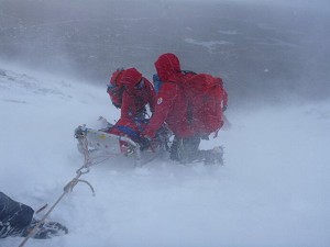
Mountain Rescue services are reliant on receiving 999 calls. However, as any hill-goer knows, mobile connection in hilly terrain may be unreliable or non-existent, making it hard to place an emergency call and affecting the geographical location data that rescuers might ideally use to help pinpoint those in need of help.
The trial aims to solve these challenges by providing a standalone drone-mounted airborne 5G NR (New Radio) network, which will enable the delivery of coverage to not-spots in remote areas and retain geographical location data for calls. Going beyond purely voice calls, the next-gen connectivity will enable picture sharing and video calling that could in some instances help rescuers guide lost parties home without necessarily needing to send personnel to physically attend, potentially saving hard-pressed teams valuable time and resources.

© Snowdonia Aerospace LLP
"This trial could transform how emergency services operate and react to life-threatening situations, and make people feel safer while enjoying national parks" said Kirsty Bright, Director of Network Innovation and Transformation at Virgin Media O2.
"We've already run our first successful test flights at the Llanbedr airport with the Snowdonia Aerospace team and look forward to demonstrating how it can support mountain rescue teams across Snowdonia."
With a wingspan of around 7m, the 'Dragon' drone should be able to circle an area for four or five hours, and it's hoped flight time will eventually be pushed to 12 hours or more.
Paul Terry, a Police Sergeant in the North Wales Police Drone Unit and Mountain Rescue volunteer, said: "Mountain Rescue is a volunteer service and there is only so much resource we have available to us. With more and more people visiting Snowdonia each year, a drone with mobile connectivity would be a powerful tool for the search and rescue teams to understand and assess a situation immediately, saving crucial time in life-threatening situations."

© Virgin Media O2
Funded to date by the Innovate UK Future Flight Challenge and a Department for Transport Drone Technology Research and Innovation Grant, the project involves Virgin Media O2, Snowdonia Aerospace, SwiftFlight Avionics, Wavemobile, and the Welsh Government.


Comments
An interesting idea… however, with (up to) 12 hours of coverage, what happens for the other 12+ hours?
Surely a well placed mast here and there would provide enough coverage for most of the area rather than relying on a drone that probably won’t be in the air unless the weather is reasonable?
That's a good question: I can ask them
I got the impression from your article that this was an emergency service, something that would be launched as required to boost the chances of communicating with and quickly finding people lost in the hills as well as making logistics for MRTs easier to organise.
I think Garethza is picturing it more as a routine 24/7 thing that'll make it easier for someone lost in the hills to call for help in the first place.
Which is it?
I am always amazed that it doesn't seem to matter where I go in the European Alps I always seem to be able to get a signal. Obviously the hut and skiing infra structure helps as it means there is the funding / desire to provide good coverage.
Exmoor, if the wind changes the signal seems to disappear. Dartmoor, very variable. Anywhere in the UK mountains it is a lottery. I'm sure drones could be useful in certain circumstances but I wonder what their weather tolerances are like - can they cope in high winds, winter temperatures, poor visibility? Personally I would prefer discrete masts to Drones if we want more coverage - I'm sure there would be many people who relish the lack of connectivity though and wouldn't want drones or masts. Balancing the 'safety net' with the desire for 'wilderness' is very tricky.
Personally, I switch my 'phone off when on mountain adventures, but keep it with me for emergencies. I understand others may choose to navigate with their 'phone - or even continue their social media life whilst in the hills!
There's no way snpa would allow it. Can't change the view in any way at all, unless it's to put a motocross trail in.