

© Iain Miller
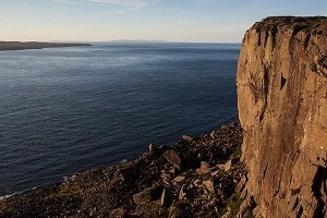
An Port (south)
ACCESS: The following three stacks are all accessed from the same launch pad. (Grid Reference 544887) From the An Port road end, follow the coastal path south over two bridges for approximately 600 metres. Leave the path and walk towards the sea, until you are at the top of the easy angled slope and slabs overlooking Berg Stack and Vertical Picnic stack. Descend to the sea level platforms facing onto the most Northern stack (Berg Stack). Berg Stack is easily visible from the road end beach as it can be identified by the two steep grooves on its North side.
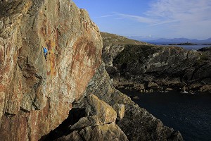
Dan Osman RIP, ** XS 4a 55m
- FA I. Miller 07/06/08
- Grid Reference 537887 This route climbs the 50 metre big daddy stack 1 KM to the south of the An Port road end by it's seaward face.
- Pitch 1, 30m, 4a, Climb the right hand side of the conglomerate wall and traverse left along the superb band of black slab until able to ascend to the open book corner. Climb the corner to a big ledge, block belay.
- Pitch 2, 25m, Climb to the summit in fine stack style. (no gear and awesome atmosphere)
Osmoregulation, DIFF, 23m
- FA I. Miller 07/06/08
- Grid Reference 538887 This route climbs the smaller of the 2 stacks in an awesome and committing location, 100m to the North of the above stack. Starting just right of centre on the seaward face, climb the black slab of immaculate rock to a stance and Jug haul to the airy twin summits.
Vertical Picnic, V.DIFF 30m
- FA I. Miller, D. O'Connor 03/08/08
- Grid Reference 544887 This route climbs the 35 mtr sea stack immediately to the south of Berg Stack, at GR544887 and approx 600 mtr to the south of the An Port road end. Access is by stack hopping across Berg Stack and a swim.
- In the centre of the seaward face, climb from the very tidal platform to a superb wee cave and spacious ledge @ 4 mtr. On superb wave washed black rock, climb the groove directly above to a smaller stance and continue to the summit on the steep left hand crack/corner line.
An Port (road end)
ACCESS: Directly “out to sea” from the road end lie the following 6 stacks. All can be accessed by paddling from the road end slip. An alternative approach is to ascend the slopes directly to the north of the slipway and skirt the cliff tops for approx 500 metres. Once you are overlooking the stacks, (Grid Reference 546894) descend to the boulder beach between “Rolling Thunder” and “Twin Arch Stack.” From this atmospheric wee beach it is possible to access by boulder hop “Twin Arch,” “Rolling Thunder” and “Realm of the Senses.” (Low tide and a calm sea required)
Realm of the Senses, Svr, 50m
- FA I. Miller 13/09/08
- The stack nearest An Port road end (Grid Reference 546893 is climbed by both it's landward and seaward faces. The landward face route starts below the landward arete. (facing the road end) Climb the immaculate rock to a grassy ramp. Follow the ramp with increased exposure and grovel to the summit. The seaward face is climbed @ Moderate for 80 Mtr up a superb ramp and deep grot grovel to the summit.
Rolling Thunder, V. DIFF, 80m
- FA I. Miller 13/09/08
- This stack is another classic wedge shape and is located on the seaward side of "The Realm of the Senses" stack @ Grid Reference 545893.This stack was climbed on it's seaward(ish) face. Just to the North of the huge seaward ramp lies a massive basin of rock walls, Scramble up the centre of the lower ramp to a rock scar niche. Climb steepy through the niche and grovel to an exposed summit.
Twin Arch Stack, V. DIFF, 40m
- FA I. Miller 13/09/08
- This unusual seastack @ Grid Reference 546894 has two legs at 90 degrees to each other, each housing a super sea arch! Scramble up the centre of the seaward face until forced to make very exposed moves up primary jungle to a tottering pin-point summit.
Fortitude in Distress, V.DIFF, 40m
- FA I Miller 13/09/08
- This classic wedge stack is found on the seaward side of the Twin Arch Stack @ Grid Reference 545894. Climb up the centre of the landward face until you can pull up onto the seaward ramp, scramble up the ramp to the summit. The summit stone has been hit by lightening and is in a burnt out condition.

© Iain Miller
An Port (North)
ACCESS: From the An Port road end follow the cliff tops for a shade over a Kilometre to the summit of the peninsula (Grid Reference 554899) overlooking and immediately to the East of the Twin Headed Stack, known locally as “An Bhuideal.” (The Bottle) Descend the very atmospheric peninsula/ridge to approx 50m before the tower to the North. From here descend the broken ground to the lonely wee south facing beach. From the huge flat semi submerged boulder, paddle the 200mtr to the landward side of the stack. Extreme caution required, this sea passage is very atmospheric. Abseil descent of the landward face.
An Bhuideal (main stack), ** SVR 4a 50m
- FA I. Miller, M. Bonner 12/04/09
- Grid Reference 549903. The following route climbs the huge arete at the Southern end of the landward face. Easily seen from the surrounding cliff tops.
- Pitch 1, 25m, 4a. Start on the excellent non tidal ledge below the centre on the landward face of the main stack. Climb up and trend left to an exposed wee ledge on the arete.
- Pitch 2, 25m, 4a. Climb the arete to the summit, every hold is a jug and the final 5mtrs will make you smile.
Tormore Group
ACCESS: From the An Port road end follow the cliff top path for approx 2KM until you are on the headland overlooking these monster stacks. (Grid Reference 557906) For Cnoc Na Mara and Lurking Fear descend the 200 metre grass slope to the lonely pebble beach facing the stacks. Keep to the grassy slopes, directly above the beach and avoid the scree to your right.
Cnoc Na Mara, *** VS 4b 152m
- FA I. Miller, A .Tees, M. McGuigan. 26/07/08
- Grid Reference 555906 This route climbs the superb landward arete of the 100 mtr “sharks fin” stack just to the South of Tormore Island.
- Pitch 1. 35m. Climb the wide groove right of centre on the landward face to a grassy ledge and block belay.
- Pitch 2, 22m. Scramble up the slab to the base of the huge knife edge arete.
- Pitch 3, 35m. Climb the arete to a peg and block belay on the ledge at it's top.
- Pitch 4, 60m. An airy pinnacle traverse along the knife edge ridge to the summit.
A Puffin Too Far, * VS 4c 150m
- FA S. Tait, I. Miller 18/04/09.
- This route climbs the seaward face of the Cnoc Na Mara. A 400 mtr channel crossing from the North end of the beach to the base of the seaward face is the easiest approach. Abseil descent of route from block and peg belays.
- Pitch 1, 25m. From the tidal ledge right of the deep recess climb the black corner to the huge seaward platform and a choice of belay recesses.
- Pitch 2, 45m 4c. Immediately left (north) of the huge seaward recess and big roofs, climb the right trending groove to below an ominous overhung corner. Struggle up the corner to a superb ledge above the void.
- Pitch 3, 40m 4b. In the centre of the ledge climb the steep left facing corner to gain the summit ridge.
- Pitch 4 40m Scramble along the ridge to the summit.
Lurking Fear, V. DIFF, 40m
- FA I. Miller 31/05/08
- Grid Reference 556906 This route climbs seaward face of the 25 mtr stack on the landward side of Cnoc Na Mara. The atmosphere is considerable!
- Pitch 1, 20mtr, Starting at the wee tidal stance at the Northern end of the seaward face, climb the steep wall of immaculate jugs to gain the easy angled ramp, pad up ramp to the sausage shaped block.
- Pitch 2, 20 mtr, Continue up ramp to a very odd pillar, make an airy move up behind it and crawl to the exposed summit.
ACCESS: Access to Tormore Island and The Hidden Stack is an involved affair! Follow the access details as for Glenlough Bay stacks. Once on the beach, “coasteer” your way West along the high water mark to the channel facing The Hidden Stack. For Tormore Island there is a further channel crossing to reach the non tidal platform at the bottom of the landward face of Tormore. From car to base of route approx 3.5 hrs!
Tormore Island, VS, 220m
- FA I. Miller, P. McConnel, A. Tees, P. Cooper 10/08/08
- Grid Reference 556908 At 150m high this is the Daddy of Donegal's Sea stacks, it can be seen from Dungloe, approx 40 KM to the North East! This route climbs the very obvious landward arete at the Eastern end of the island. This feature can clearly be seen from any position along this coast overlooking the stack. Access to this stack by land is a very involved affair a boat approach is recommended.
- Descent is by 4 abseils back down this route using the block and peg belays described
- Pitch 1. 45m Starting on the non tidal ledge in the centre of the landward face, directly opposite the secret 35 mtr stack. Climb the blunt arete to the right of the vertical basalt vein, follow the corners and ledges on superb quartz to a large block belay.
- Pitch 2. 40m Continue up the arete on slabby mixed ground to a large ledge below the huge capping roof, peg belay.
- Pitch 3. 45m Climb direct on superb rock to the left end of the huge roofs and become increasingly aware of your surroundings. Pass the roofs on the left and continue on mixed ground to a huge ledge and peg belay.
- Pitch 4. 45m Climb gearless, near vertical grass to an exposed wee ridge, follow the ridge for 15 metres to a block belay.
- Pitch 5. 20m Scramble up the grass covered ridge to the summit.

Glenlough Bay
ACCESS: From the An Port road end follow the cliff top path North for approx 3 KM. Once you pass the Tormore viewpoint (Grid Reference 557906) continue to follow the cliff tops as they descend into Glenlough Bay. At Grid Reference 567904, descend to the wide gully immediately to the South of the large ominous looking buttress. Follow the stream down this gully until approx 70 metre above the sea, traverse north for 50 metres and descend the scree slope to the beach. (Directly below the ominous buttress)
Grid Reference 568908, the following two routes climb the Landward face of the huge tent shaped stack in the centre of the bay.
Darkness Descends, DIFF, 95m
- FA I. Miller 25/11/08
- From the large crater/pod at the bottom left of the landward face (Southern end), follow the right trending hand crack up the slabs(Northward). Continue right (North) through heather, grot and atmosphere to gain the foot of the North Ridge. Scramble up the ridge to the summit.
Rainman V.DIFF, 75m
- FA I. Miller 25/11/08
- From the pod/crater at the bottom (southern end) of the landward face climb direct to the summit, up the superb slabs and positive holds!
Jenga, *** E2 5a, 50m
- FA I. Miller, D. Oconnor 28/12/08
- Grid Reference 569908 This 30 metre quartz tower sits on the beach between the high and low water lines. This tower is an extremely serious climb, a fall from the last 12 metres would be fatal.
- Pitch 1: 15m 4a. Starting on the high water line at the southern end of the landward face, climb the knobbly quartz to a small stance and make a superb rising traverse above the roofs/cave towards the sea to a large airy ledge above the void.
- Pitch 2: 35m 5a. Follow a raising traverse North to the centre of the seaward face. Climb the right trending fault to the southern end of the knife edge summit ridge. Scramble along ridge to summit.
Gull Island
Gull Island E1 5a 145m
- FA I. Miller, M. Bonner 24/04/09
- GGR 613924. This route climbs the outrageous, soaring landward arete of this beast. Access is a monster walk in from GR613889 over Slievetooey (472m). Access to base of the stack is a 100m steep grass/mixed ground scramble to truly a atmospheric location on the boulder beach at the base of the stack. Descent from summit is by guile and 2 abseils down the route. This route has to be seen to be believed!
- Pitch 1, 50m, 4a. To the West of the landward arete climb the huge corner crack until it terminates. Traverse right & ascend the ramp to gain arete & PB. (2 good gear placements in 50m, fall & U will die)
- Pitch 2, 50m, Continue up the Arete by a very atmospheric scramble to the big block @ the top of the boulder field.
- Pitch 3, 45m, Crimp left and ascend up superb rock, continue to the summit by your easiest route.
UKC Articles and Gear Reviews by iain miller
- Donegal Sea Stacks - Text Guide 19 Oct, 2010


Comments