


In this feature from the British Mountain Guides, a qualified and experienced guide takes you through one of the most coveted and beautiful routes in the Western Alps.
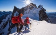
The Rochefort Ridge is an utterly classic exposed snow ridge requiring good balance and crampon technique with some surprisingly bold and loose rock climbing to gain the summit of the Aiguille de Rochefort.

© Owain Jones
 © Owain Jones
Mountain: Aiguille de Rochefort 4001M
Ascent: West Ridge (The Rochefort Ridge)
Return: Described as a return trip.
Length: 4 to 5 hours for the ascent. 3 to 4 hours for the return.
Grade: AD - Take care gaining summit of the Aiguille de Rochefort with surprisingly bold and loose rock climbing.
Starting Point: Torino Hut +39 0165 84 40 34
Quickest Approach
From Chamonix:
Aiguille Du Midi lift then the Helbronner lift takes you straight to the hut. This is weather dependant and costly.
Via Mt Blanc Tunnel (quite costly around 47 Euros return) to Italy and take the La Palud lift. The flight of stairs to the hut are infamous and will have you wilting silently whilst trying to look unruffled in front of your partner!
Aesthetic Approach:
Aiguille Du Midi lift then down the snow arête and traverse of the upper Vallee Blanche to the hut. Stunning scenery good acclimatization! Quite tiring in reverse avoid doing this after the Rochefort . Go down the lift to Italy and get the bus or do it the next day after another hut night.
For a detailed description see The 4000m Peaks Of The Alps by Martin Moran page 271 (ii)
Guidebook:
The Chamonix Rockfax covers this route and plenty more.
Snow, ice and mixed Volume 1 by Francois Damilano, JM Editions is a must buy with super detailed photographs of the route.
The 4000m Peaks of the Alps by fellow guide Martin Moran, published by the Alpine Club is indispensable for anyone serious about 4000m peaks. One of the best Alpine guidebooks ever written!
Map:
Institut Geographique Nationale (IGN)
3630 OT Chamonix Massif Du Mont Blanc
Summary:
One of the most coveted and beautiful routes in the Western Alps, its narrow corniced crest made famous by the doyens of Alpine photography.
Climbing any Alpine route is the final piece of the jigsaw preceded by hours of perusing guidebooks, cross referencing and speaking to fellow climbers with first hand experience whenever possible. This degree of preparation and mental psyching up for the task is what makes the final outcome special and uniquely rewarding.
The Rochefort Ridge is a perfect example of the full Alpine experience, requiring research and an understanding of the topography prior to an ascent.
Topography:
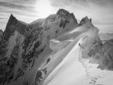
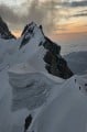
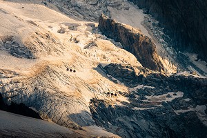
The Rochefort Ridge (West Ridge) as far as the summit of the Aiguille De Rochefort, is actually the first part of a much bigger and more committing traverse known as the Arete de Rochefort Traverse.
This continues over the Dome de Rochefort (see photo photo at the top) and the Calotte de Rochefort with technical climbing and abseiling to the Col des Grandes Jorasses where there is a bivouac hut called the Canzio.
This is a very remote place with no easy escape either to Italy or France. For more detail refer to The 4000m Peaks Of The Alps, by Martin Moran, page 315.
Most Alpinists going this far are intent on continuing from the col (after sleeping at the Canzio) over all the tops of the Grandes Jorasses. Descending eventually from Point Walker down to the Boccalatte hut in the Italian Val Feret. This is a major undertaking and one of the most coveted ridge traverses in the Alps.
This is the reason for the obvious popularity of the first section as far as the Aiguille de Rochefort as it can be done in a day as a return trip.
The Route:
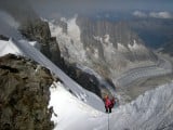
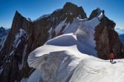
Very detailed descriptions are available in the aforementioned guidebooks. So I will focus on the key points of the climb. Initially the route leaves the hut and crosses the Col du Geant (see photo below), a huge snowy plateau leading to mixed ground on the SW face of the Dent du Geant 4013m. One of the most stunning 4000m peaks around.
The lower section of this face needs good route finding (very good line photos in Damilanos' and Moran's guides) in order to gain a place known as the Salle a Manger (2 to 2.5 hours) This large snowy shoulder is the start for both the Dent du Geant and the Rochefort Ridge. This section therefore can be busy and hazardous due to parties above dislodging rocks. In dry conditions the same applies. Good snow cover makes for a safer ascent and an early start is wise. The hut guardian can advise on best start times and current conditions.

© Owain Jones
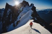
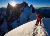
From here head right to the start of the snow arête (see photos below) and follow the narrow crest over dips and subsidiary tops. An obvious steep descent on 50 degree snow leads down to a gap. Either down climb or abseil as there are fixed anchors. Its actually easier on the way back!

© Owain Jones
From here continue along the arête to the base of the summit wall. This has climbing of UIAA 2/3 and is a bit loose. The rock also lacks pro. Take some small to mid nuts and cams. Refer to aforementioned guidebooks for more detail.
Descent:
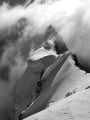
Be careful getting down the summit buttress (see photo below) down climbing skills are needed here. Parts can be abseiled but anchors are poor. Retrace your steps to the Salle a Manger. From the Salle a Manger continue down the line of ascent back to the Torino Hut (3 to 4+ hours). Obviously it is later in the day so down climb carefully don't rush and be wary of dislodging rocks on others as well as looking after yourself.
 © Owain Jones
 © Owain Jones
More info on the British Mountain Guides
A British Mountain Guide is an International Federation of Mountain Guide Associations (IFMGA) Guide, which put simply, means an internationally qualified guide with the knowledge and skills to lead parties in the world's most challenging mountain environments.
From first steps to the biggest objectives, a British Mountain Guide is an expert in techniques and safety, and a reliable companion for your adventures.
Logistics
Accommodation Advertise here
No Premier Listings found in this area
Instructor/Guides Advertise here
No Premier Listings found in this area
Outdoor Shops Advertise here
No Premier Listings found in this area


Comments