UKC

The Ridges of Norway's Jotunheim

© Margrethe Seeger Halvorsen

Majestic, wild and adventurous, the Jotunheim are the true alpine mountains of Norway. Many exceed 2000m, and if long sharp ridges are your thing then the area is a goldmine. Although the weather can be doubtful, this just adds to the dramatic experience.

Skagastølstindene, Hurrungane, Jotunheim  © Jamie Simpson - Alpine Dragons
Skagastølstindene, Hurrungane, Jotunheim
© Jamie Simpson - Alpine Dragons, Aug 2017

The range is located in the southern central area of Norway and covers an area roughly 3500km square. The mountains are sculpted by glaciers eating away at the sides to form steep dramatic peaks interconnected with sharp exposed ridges that offer classic routes from exposed scrambles through to testing alpine traverses. Here are some of the best...

Margrethe nearing the summit of East Styggedalstinden (Gjertvasstinden in the background), Hurrungane, Norway  © Jamie Simpson - Alpine Dragons
Margrethe nearing the summit of East Styggedalstinden (Gjertvasstinden in the background), Hurrungane, Norway
© Jamie Simpson - Alpine Dragons, Aug 2017

History

Although these mountains had been explored, mainly by farmers and hunters for some time, it was the ascent of one of Norway's most cherished mountains, Store Skagastølstind (Storen) by W.C.Slingsby that is considered the birth of "tinderangling" (mountain climbing) in Norway. It was late one evening on the 21st July 1876, that W.C.Slingsby left his friends at a col between Vetle and Store Skagastølstinden (now named Mhons Skar) after ascending the glacier (now called Slingsbybreen) and climbed alone to the summit, which at this time was considered impossible.

Evening light over Store Skagastølstind (Storen) t.v, Store Austabotntind, (centre) & Store Ringstind (large snow sl  © Jamie Simpson - Alpine Dragons
Evening light over Store Skagastølstind (Storen) t.v, Store Austabotntind, (centre) & Store Ringstind (large snow sl
© Jamie Simpson - Alpine Dragons, Aug 2017

Hurrungane

Located in the southwest of the Jotunheim, the Hurrungane is considered the most alpine of all the areas in this range. It is home to spectacular mountains, interconnected with sharp exposed ridges and steep walls that crash down to glaciers.

Base: Turtagrø

Storen or Store Skagastølstinden (2406m)

Hurrungane, Jotunheim - Styggedals Traverse  © Jamie Simpson - Alpine Dragons
Hurrungane, Jotunheim - Styggedals Traverse
© Jamie Simpson - Alpine Dragons, Aug 2017

An ascent of Store Skagastølstind (Storen) is highly recommended, and although there are shorter, more direct routes to the summit it would seem rather rude not to ascend this majestic peak, often referred to as "The jewel in the crown" by the North ridge (Skagastøls-traverse) as this is considered one of the finest routes to the summit.

Route: Skagastøls-traverse

Summary: This long, arduous route follows an exposed ridge, mainly sustained scrambling with sections of climbing up to grade 4 and abseils. The route takes between 13-17 hours from Turtagrø and once on the ridge, water is absent. If the ridge is dry and snow free, many parties will not feel the need for a rope on many sections. However, a dusting of snow changes everything, although good snow conditions can make certain sections of the ridge significantly easier.

Considered by many to be one of, if not the most, spectacular ridge traverse in Norway - quite an accolade.

Equipment: 2 x 60m rope. The abseil from Storen is 55m. Light mountain rack.

The mountain is heavily guided during the July and August, especially at the weekends, however, if you can flexible with your time you can have the mountain to yourself.

Alternative routes include the popular Hefties and Andrew Renne.

The original route ascending Slingsybybreen (glacier) is less frequented these days due to its length and general glacier condition. However, I am left wondering if its popularity has decreased because other routes are shorter, easily accessible from Turtagrø and require less alpine skills.

There are also high-quality rock climbs on the main peak including some big wall outings.


Gjertvasstinden (2351m), Styggedalstindane (2387m), Sentraltinden (2348m), Vetle (2340m), Midtre (2284m) and Nordre (2167m) Skagastølstindane

Just before the descent to the col between West Styggedalstinden and Sentraltinden  © Margrethe Seeger Halvorsen
Just before the descent to the col between West Styggedalstinden and Sentraltinden
Jamie Simpson - Alpine Dragons, Aug 2017
© Margrethe Seeger Halvorsen

Route: Styggedals / Skagastøls traverse (West to east)

Summary: This long, demanding alpine traverse passes through some of Norway's most spectacular mountain scenery. Experience in alpine mountaineering is essential, as you will be tested on glaciers, steep crevassed snow slopes, snow arêtes, long sections of exposed scrambling, climbing up to grade 4, numerous abseils and often tricky route finding.

Although this traverse can be undertaken in a single long day during the summer months, lingering is highly recommended with a high mountain bivouac. A magnificent experience!

Hurrungane, Jotunheim - Gjertvassbreen, Gjertvasstind and Styggedalstind  © Jamie Simpson - Alpine Dragons
Hurrungane, Jotunheim - Gjertvassbreen, Gjertvasstind and Styggedalstind
© Jamie Simpson - Alpine Dragons, Aug 2017

Equipment: 1 x 60m rope, mountain rack, axe and crampons, snow/ice anchors and abseil cord.

Once on the ridge, there is very little water to be found. During the summer months, light bivouac equipment might be acceptable, however, on my own traverse in August the night time temperatures fell to -6 Celsius, and we were both very happy to have sleeping bags, extra warm jackets and a stove.

The ridge can be traversed in both directions. If you decide to start at Turtagrø hotel, and traverse east to west the normal route is to ascend the steep slopes from Gjertvassbreen (Glacier) to Gjertvassskaret (col). The conditions on these slopes vary significantly, and it's not uncommon for parties to utilise snow /ice screw anchors on this section. Alternatively, you can ascend Gjertvasstinden. However, this involves a very long approach from Turtagrø.


Store Austabotntind (2204m)

Store Austabotntind as seen from Midtre Austabotntind.   © Jamie Simpson - Alpine Dragons
Store Austabotntind as seen from Midtre Austabotntind.
© Jamie Simpson - Alpine Dragons, Jul 2014

Store Austabotntind is a majestic mountain, standing quite alone from the rest of the Hurrungane massif. Its airy and exposed ridges, guarded by four glaciers that are eating away at its sides, make for a spectacular alpine peak. It is not a technical climb, even though appearances might suggest differently. However, a rope is advisable on the more exposed sections and certainly the final spectacular summit block!

Route: North west ridge

Summary: Climbing up to Norwegian 2/3 (4 if a direct route is taken), abseil or down climbing. Exposed arête.

Equipment: Light mountain rack. 1 x 60m rope. Alternatively, if you intend to rappel the slab it can be done with 2 x 60m ropes or down climbed with just a 30m section of rope. If the slab or ridge is very snowy crampons, axes and snow anchors are essential.

Summit block - Store Austabotntind  © Jamie Simpson - Alpine Dragons
Summit block - Store Austabotntind
© Jamie Simpson - Alpine Dragons, Jul 2014

Smørstabbtindane

Located in the Northwest Jotunheim these alpine mountains interconnected by sharp exposed arêtes are clustered around Leirbreen (glacier). This area has historically been the base for many Norwegian mountaineering and glacier courses.

Kalven (2034m), Skeie (2118m), Veslebjørn (2150m)

Smørstabbtindan. From left to right. Store Smørstabbtinden, Kniven, Sokse, Skeie, Veslebjørn, Kalven and S  © Jamie Simpson - Alpine Dragons
Smørstabbtindan. From left to right. Store Smørstabbtinden, Kniven, Sokse, Skeie, Veslebjørn, Kalven and S
© Jamie Simpson - Alpine Dragons, Apr 2011

Base: Krossbu

Seen from Sognfjell, this circe of mountains surrounding the gentle Leirbreen inspire the alpinist to venture forth. It is possible to traverse all the mountains around the glacier in one long expedition, however, for this article the main focus will be on the first half from Kalven to Bjørnskardet (a col between Veslebjørn and Sokse). The other mountains in the range can be climbed separately. Veslebjørn is sometimes referred to as "Lille bjørn" (little bear).

The summit of Vesle Bjørn with the ridge of Skeie in the background   © Jamie Simpson - Alpine Dragons
The summit of Vesle Bjørn with the ridge of Skeie in the background
© Jamie Simpson - Alpine Dragons, Apr 2011

Route: Smørstabbtindane traverse

Summary: Glacier crossing, snow slopes, climbing up to grade 4, exposed scrambling, several abseils including an unusual abseil. Once you join the glacier there will be no water until your return to land. Traversing along the exposed ridge towards Skeie it is as if the entire ridge overhangs Smørstabbreen (glacier). The climbing between Kalven and Skeie is not difficult, mainly grade 3 with some short sections of 4. If the weather is doubtful it is possible to just climb this section and abseil back to the col. The glaciers especially Bøverbrean are often used by glacier courses in the summer months and seracs seen at the top of this glacier where its meets Smørstabbreen are worth exploring. It is advisable to use a rope within the area as I have personally seen several participants on courses punch through.

photo
Late in the day. One of the abseils from the NE ridge between Veslebjørn and Bjørnskardet (col)
© Jamie Simpson - Alpine Dragons, Jul 2014

Equipment: 2 x 60m ropes, mountain rack, ice axe and crampons, snow and ice anchors (depending on conditions). If you intend to undertake the entire traverse bivouac equipment will be required.

Uranos massif

Uranostinden (left) and Langestavltiden (right).  The Uranos glacier in the middle   © Jamie Simpson - Alpine Dragons
Uranostinden (left) and Langestavltiden (right). The Uranos glacier in the middle
© Jamie Simpson - Alpine Dragons, Sep 2016

Uranostind (2157m)

Located in the southwest section of the Jotunheim, this majestic peak dominates the landscape when seen from Tyin. Its conical shape forms a charismatic peak and does not fail in catching the eyes of all that pass through this landscape.

Base: Fondsbu

Even though its profile is of an alpine peak, it can be ascended with relative ease via Uranosbreen, and is within many people's reach. The south ridge, however, is a different matter and forms a long elegant ridge with occasional sections of exposed easy climbing. Out of all the mountains I have climbed in the Jotunheim, this mountain and ridge profile forms the purest essence of alpine mountaineering. While scrambling along the ridge, the sides of the mountain thunder down to a glacier on one side and lake on the other. Beautiful.

photo
Uranostinden, Norway
© Jamie Simpson - Alpine Dragons, Sep 2014

Route: South ridge

Summary: Mainly scrambling grade 2 with short sections of 3 along an exposed arête

Equipment: Light mountain rack, 1 x 60m rope, snow / ice anchor, crampons, axes and crevasse rescue kit

Stølsnos Massif

Falketind (2067m)

Falketind in Autumn clothing, waiting for full winter  © Jamie Simpson - Alpine Dragons
Falketind in Autumn clothing, waiting for full winter
© Jamie Simpson - Alpine Dragons, Sep 2015

Falketind is a very charismatic and striking peak located in the Stølsnos massif which is located in the South west area of the Jotunheim.

The east ridge first climbs over Falkeungen before following a narrow arête until it is possible to climb Falketind proper to the summit. The route is less popular than many of the other ridges due to its seriousness and that it involves 11 pitches of actual climbing. It forms a very fitting route to the summit of this historically important mountain.

Route: East ridge

Summery: Norwegian 5 (Mainly 3 to 4), glacier crossing and route finding. Descent via Pioneer route grade 2/3, steep snow (40 degrees) and glacier travel.

Equipment: 2 x 60m ropes. Full mountain rack - in addition, some larger cams are useful. Abseil cord. Crampons, axe and a snow anchor might be useful for the descent.

Looking down the east ridge of Falketind  © Jamie Simpson - Alpine Dragons
Looking down the east ridge of Falketind
© Jamie Simpson - Alpine Dragons, Aug 2016

Gjendealpene

Located in the southern section of the Jotunheim, these beautiful mountains lie within a remote and wild landscape found between Gjende lake and Bygdin lake. They are well worth a visit, even if just to get away from it all. Torfinns traverse isn't a technically demanding tour, as most of the difficulties can be abseiled. However, it is remote - beautifully remote.

Looking back to Øystre Torfinnstinden from Midtre - Photo Courtesy of Ola Døhl  © Ola Døhl
Looking back to Øystre Torfinnstinden from Midtre - Photo Courtesy of Ola Døhl
© Ola Døhl, Aug 2016

Torfinnstindane (Østre (2119m), Midte (2110m) og Vestre (2085m)

Base: Fondsbu or Beitstølen.

Route: Torfinnstind traverse

Summary: Exposed scramble with sections up to grade 3 plus several abseils. If the ridge is dry many confident parties may only use the rope for the abseils, however when wet the ridge becomes quite slippy.

Equipment: Light mountain rack. 1 x 60m rope. Abseil cord.


Logistics

When to go

The most popular times are Spring (March to May) and Summer to early Autumn (July to September). July is busy as this is the time most Norwegians go on holiday. Autumn is a wonderful time to visit the Jotunheim; the colours are beautiful, with winter starting to creep in at the higher elevations and often the mountains are empty. Winter is also an option. However, the approaches will be much longer, and you will need to use skis.

Getting there and around

Flights: Flying into Oslo is the easiest option.

Car hire: Numerous car hire companies at Oslo Airport.

Public transport: Regular bus transport from Oslo to main towns on the periphery of the Jotunheim and local buses/transport can take you into key areas.

Roads

From Oslo main airport it takes approximately three hours to drive to the Jotunheim national park.

The Jotunheim is circumnavigated by roads with very little internal access apart from gravel roads into Fondsbu, Glitterheim or Leirvassbu. Boats on the lakes Gjende and Bygdin can also take you into the heart of the Jotunheim.

While having a car gives greater flexibility, it is still possible to travel to the Jotunheim by public transport. Buses regularly run from Oslo to the main centres throughout the National park and further into key locations, for example, Turtagrø, Krossbu and Fondsbu.

photo
Jotunheim map
© Kartverket

Norwegian grades

The Norwegian grading system is a mystery unto itself. While sport grades in the valley are fairly consistent from crag to crag, the same cannot be said for traditional grades. In the high mountains, on popular routes, the grades are generally consistent. However, there are errors in the guidebook, and even with the advent of the new Jotunheim guidebook, the same mistakes exist. On the routes described in this article, the grades are generally accepted as the accurate representation of the difficulties encountered for good dry conditions using mountaineering boots. Add rain, snow or ice, which is not uncommon, and the difficulties will increase markedly.

Grade comparison tables I have seen are often misleading as Norwegian grades tend to cover a larger range of difficulties than British grades and do not take into account quality of protection or how sustained a pitch is.

Norwegian

British

3

D/VD

4

S

4+

S/HS

5-

HS/VS

5

VS

5+

VS/HVS

6-

HVS/E1

6

E1

Norwegians grade for the pitch and not for the route. For example, Styggedals / Skagastøls traverse has only individual pitches graded, while the 50 degree crevassed snow slope to access the ridge between Gjertvasstinden and Styggedalstinden is ungraded and described as "steep", which is somewhat ironic as this slope requires more alpine experience than any other section of the traverse. Likewise, there are often bouldery type sections, which are rarely described in any text which are more technically demanding than any described pitch.

If in doubt think Scottish VS and get ready for anything!

Participants on the summer mountaineering course near the summit   © Jamie Simpson - Alpine Dragons
Participants on the summer mountaineering course near the summit
© Jamie Simpson - Alpine Dragons, Jul 2016

Information on conditions

While each summer a new riot of life spreads into the high mountains, winter's icy grip is seldom far away and this should be taken into consideration when planning your trips.

For the most reliable information it is best to speak to local guides at one of the mountain hotels. Most information is shared through a collection of private social media groups and blogs, but very useful information can also be found on the following web sites:

Accommodation Advertise here

No Premier Listings found in this area

Camping off the beaten track, which in Norwegian law is 150m from habitation, is acceptable and free. Within key locations there are many campsites, cabins and hotels to suit all budgets, although this being Norway many even at the cheaper end will seem expensive. Mountain huts throughout the national park are a mix of private and Den Norsk turistforening (DNT) huts. Many are service huts meaning you need to pay for food, while others are what is called self-service where you can buy and cook food. What we have done in the past is camp until we cannot take it anymore and then spend one night in a DNT hut to dry out. Alternatively, we have camped a distance away and paid for a day visit, got dry and fed, then wandered back to the tent to sleep.

Remember: you need a DNT key to get into the huts! Many huts are hermetically sealed during the winter months. Check with DNT for opening times.

Most Norwegian tents all seem to have a sizeable porch on them which says a lot about the weather. A good sleeping bag is recommended. On our last outing, bivouacking at 2000m, the night time temperature fell to -6°C in late August.

Mosquitoes and midges can be a problem and if you're a magnet to these creatures (as I am) then some sort of protection is required. On the glaciers the sun can be very intense so good quality glacier sunglasses and sun block are recommended.

Warning: The huts can set a rather romantic atmosphere and you might suddenly find yourself proposing to your Norwegian girlfriend, followed by buying a three-course meal, a glass of wine and then some chocolate. The following day the proprietor provides a bill which will be quite staggering and cools even the warmest of hearts.

Other options

Over the last few years, the hotel industry has had stiff competition, and out of season it is possible to pick up some bargains. Thon hotels is one of them.

Norwegians have embraced Airbnb, and you will often find good overnighting possibilities with much better hospitality than more traditional venues.

It is typical to provide your own sheets at DNT huts and privately run cottages. There is quite a trade in lightweight sheet sleeping bags, pillows and sheets in Norway just for this.

Jotunheim July 2009  © Jamie Simpson - Alpine Dragons
Jotunheim July 2009
© Jamie Simpson - Alpine Dragons, Jul 2009

Guidebooks and other resources

Online:

Simply the best online information can be found on James Baxter's wonderful website scandinavianmountains.com

Another resource in English is westcoastpeaks.com The author has a good sense of humour that shines through his writing.

Peakbook is also available, though most people write in Norwegian on this site.

Books:

James Baxter has written a good book called Hurrungane, that covers in detail the Alpine mountains of the Jotunheim.

Fotturer i Jotunheimen by Helge J. Strandal and Jon Hagen is a good book (written in Norwegian). It contains some wonderful photos marked with routes and maps. It is also a good size that can easily be carried.

Norges Fjelltopper over 2000 metres written by Morten and Julia Helgesen is also a good book (written in Norwegian) with excellent photographs, maps and details. It is a coffee table style book and is not easily carried about. Often found dog-eared in DNT service huts.

The Norwegian Alpine club guidebook is a good guide describing routes but there is very little in the way of pictures, maps or enthusiasm. It has been recently republished, but unfortunately with the same errors and lack of information as the previous edition.

Maps:

The Norwegian state has made all map source data free, and they can be found here

Norge-Serien provides the best hard copies, and you can download them to smartphones

Occasionally you can find old State produced maps, faded and forgotten in the corner of a tacky tourist shop. They are utterly useless, out of date and have the weather resistance of toilet paper. Walk on by!

Information provided on maps and at huts should be seen with a rather humorous scepticism. Norwegians think the path should be roughly placed on the map, a general adventurous approach rather than fact. Information provided about bridges between huts should be regarded as "we think it's still there" and "it was the last time we looked" and so when you arrive soaked at the next hut after an epic river crossing to find another note pinned on the wall stating, "we meant the other bridge" one should try and smile about it. After all nature is nature and people have differing opinions.

Margrethe arrives at Gjertvasskaret just before the sun arrived.  © Jamie Simpson - Alpine Dragons
Margrethe arrives at Gjertvasskaret just before the sun arrived.
© Jamie Simpson - Alpine Dragons, Apr 2017

Gear

It is advised to carry a mountaineering axe and crampons on many of the routes described.

Although the glaciers in Norway are considered more friendly than glaciers in other parts of the world, they should still be treated with respect. All the routes described in this article cross a glacier at some point and I have personally punched through several snow bridges myself or witnessed course participants doing the same. It is advised, depending on conditions, to carry snow anchors and ice screws on many of the routes described.

Although the towns on the periphery of the Jotunheim have numerous gear shops, specialist equipment will only be found for a hefty price in the major towns and cities. In an emergency, it might be possible to order from a shop in Oslo and get the items delivered to one of the mountain hotels.

Outdoor Shops Advertise here

No Premier Listings found in this area

Food and Supplies

All towns on the periphery of the Jotunheim have sizeable supermarkets, often with Sunday openings. Gas canisters can be bought nearly anywhere.

Keeping the cost down

Norway certainly isn't cheap. However, the cost can be significantly reduced by good planning. Shopping in larger supermarkets instead of smaller shops and gas stations will reduce the cost significantly. Camping wild is free. Camping in the vicinity of some mountains hotels (Krossbu, Turtagrø and Fondsbu) can incur a small cost. However, you can use the toilets, showers, drying room and sit in the warmth.


About Jamie Simpson

Jamie Simpson head shot  © Jamie Simpson

Jamie is the senior instructor and manager at Alpine Dragons and Valdres Fjellguider (The Norwegian side of the company). He holds Alpine, Glacier, Ice and Avalanche instructor qualifications through the Norsk Fjellsports Forum, which is the home-grown Norwegian qualification system.

Jamie grew up in the English Lake District, where he first started exploring the valleys and mountains. He soon, however, moved to Scotland and undertook a degree in geology continuing his apprenticeship in climbing and mountaineering. As a geologist Jamie has worked in many places, including Norway where he fell for the land and one of its inhabitants. After a bit of moving about they bought an old farm in Valdres and started Alpine Dragons and Valdres Fjellguider.

Jamie's philosophy is simple; The mountains are for everyone, respect both people and the environment, and try as best you can to stay in the moment.


11 May, 2018

When to go - is the area like the Rondane where a lot of tourist accommodation simply shuts at the end of August with no warning? That could be a problem if people are expecting to stay somewhere at short notice. Apart from that it looks good.

Thanks for your comment.

The huts  "opening and closing" times are often subjected to conditions, i.e. snow conditions.  

As most of the huts in the Jotunheim are privately owned, you will need to check each website for the opening and closing times.  They can be found at https://www.ut.no.

As most huts are run at a local level its best to check in the shoulder seasons if they are open.  

After slogging our guts out through sleet to the top of Fannaråken Hytta, we found it not only locked but hermetically sealed for the winter. When I raised the matter with DNT, they said.... Sorry about that. 


11 May, 2018

I remember skiiing up Storen in the dead of winter, digging the hut out and then discovering it had been down classed from hut to emergency shelter.  It was like the ice box of a fridge.  Out of the wind and worst of it though :-)

Fantastic area

Cheers

Toby

11 May, 2018

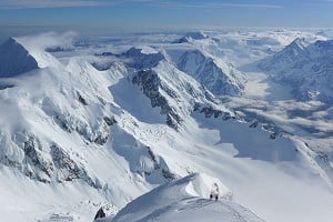
Super article although I would say fans Lyngen might contest the claim that "the Jotunheim are the true alpine mountains of Norway", not saying Jotunheim isn't alpine but Lyngen is pretty alpine too! :)

From my limited experience in North Norway, grades seem rather inconsistent. I did a great 5 or 5+ route on Kvaloya that felt as tough as 6s I had done on Lofoten, so 5+ can be solid E1! Maybe the southern Norwegians aren't as tough as their arctic brethren though. ;) 

11 May, 2018
Sunnmore is also pretty fantastic but The ridges in Jotunheimen are pretty super. 


Whats the situation with snow  on these things at the moment? Thinking of next weekend


More Comments
Loading Notifications...
Facebook Twitter Copy Email